

THE GEOGRAPHY AND GEOLOGY OF OHIO.
By , State Geologist.
Edward Orton, LL. D., was born at Deposit, Delaware county, New York, March 9, 1829. His parents were Rev. Samuel G. Orton, D. D., and Clara Gregory Orton. The Ortons are first known in New England about 1640, the name appearing in this year in the records of Charlestown, Massachusetts.
Thomas Orton came to Windsor, Connecticut, in 1641 or 1642. From Windsor certain members of the family emigrated in the year 1700 or thereabouts to the new settlements of Litchfield, which was then on the edge of the wilderness. There were thus two branches of the family—one at Windsor and one at Litchfield. The Litchfield Ortons lived for more than a century on what was known as Orton Hill, South Farms. They were well represented in the Revolutionary war, but beyond this do not appear to have taken prominent part in public life. They seem to have been a quiet, home-loving, fairly thrifty stock, possessed of a good deal of family affection and interest.
Miles Orton, the father of the Rev. Samuel G. Orton, was a soldier in the war of 1812 and died soon after the war.
Samuel G. Orton was born at Litchfield and was brought up on a farm until 20 years old, when, under the ministry of Dr. Lyman Beecher, he was encouraged to seek a liberal education. He was obliged to support himself by his own labor both while preparing for college and during his entire course. He graduated at Hamilton College in 1822 and studied theology in New Haven. He was an honored minister in the Presbyterian Church for nearly 50 years; most of which time he spent in Western New York.
Edward Orton passed his boyhood in his father’s country home at Ripley, Chautauqua county, New York. He acquired here a knowledge of and life-long interest in country life, often working among the neighboring farmers for weeks and even months at a time. He was fitted for college mainly by his father, but spent one year in Westfield Academy and another in Fredonia Academy. He entered Hamilton College, the college where his father had graduated, as a sophomore in 1845 and graduated in 1848. He taught after graduation for a year in the academy of Erie, Penna. He entered Lane Theological Seminary, Cincinnati, in 1849, and was under Dr. Lyman Beecher’s instruction. He withdrew from the seminary on account of a temporary failure of his eyes, but after a year or two spent on the farm and in travel he resumed the work of teaching, becoming a member of the faculty of the Delaware Institute, Franklin, Delaware county, N. Y. In college his chief interest had been in literary and classical studies, but in the institute he was set to teaching the natural sciences and a latent taste for these studies was soon developed. He pursued the studies of chemistry and the natural history branches with special interest, and to prepare himself better for teaching them took a six months’ course in the Lawrence Scientific School of Harvard University, in 1852, studying under Horsford and Cooke and Gray. Finding that his theological creed was giving way under his later studies he sought to avert the change by more thorough investigation in this department, and entered Andover Seminary to attend for a year Prof. Park’s lectures on theology. The experiment was successful to the extent of arresting the change in his views, but after a few years the process was resumed and ended in the replacement of the Calvinistic creed in which he had been brought up by the shorter statements of Unitarianism. In 1856 he was called to the chair of natural science in the State Normal School of New York, at Albany. He held this position for several years, resigning it to take charge of Chester Academy, Orange county, N. Y. After spending six years in this position he was called in 1865 to Antioch College, Yellow Springs, Ohio. He was first made principal of the preparatory department, then professor of natural history, and finally in 1872 president of the institution. This last position he held but for one year, resigning it in 1873 to accept the presidency of the Ohio Agricultural and Mechanical College, now the State University, at Columbus. He was also made professor of geology in this institution at the same time. He held the presidency for eight years and retained the professorship of geology after resigning the former place.
During his residence in Yellow Springs the State geological survey was organized under Newberry. Prof. Orton became in 1869 a member of the geological corps, being appointed thereto by Governor R. B. Hayes. He was reappointed by Governor Noyes, and after Newberry’s withdrawal from the field was appointed State geologist by Governor Foster and at a still later day by Governor Hoadly. This latter position he has held in conjunction with the professorship of geology in the State University.
He was married in 1855 to Mary M. Jennings of Franklin, N. Y., who died in 1873. In 1875 he was married to Anna Davenport Torrey of Millbury, Mass.
In addition to his geological work proper Prof. Orton has taken an active interest in the applications of geology to agriculture and sanitary science and especially to the questions of water supply and sewerage of the towns of Ohio.
A.
GEOGRAPHY OF OHIO.
The boundaries of Ohio, as fixed in the enabling act by which, in 1802, it was admitted into the Union, were as follows: on the east the Pennsylvania line; on the south the Ohio river to the mouth of the Great Miami river; on the west a due north line from the mouth of the Great Miami; on the north an east and west line drawn through the southerly extreme of Lake Michigan, running east after intersecting the meridian that makes the western boundary of the State until it intersects Lake Erie or the territorial line, and thence, with the same, through Lake Erie to the Pennsylvania line.
The eastern, southern and western boundaries remain unchanged; the northern boundary has been slightly modified. As finally established by Congress in 1836 it consists of a direct line, or in other words of the arc of a great circle instead of a parallel of latitude, from the southern extremity of Lake Michigan to the most northerly cape of the Maumee Bay and thence northeast to the boundary line between the United States and Canada, and along this boundary to its intersection with the western boundary of Pennsylvania.
The change here indicated was provided for in the enabling act above referred to, and also in the constitution bf Ohio which was established in 1802, but the cause that led to making it in 1836 was a dispute that had arisen between the State of Ohio and the Territory of Michigan as to jurisdiction along this border. The dispute assumed the character of a war of small proportions and of short duration during the administration of Governor Lucas, of Ohio, an account of which is given elsewhere in this work.
The territory of the State can be further defined as included between 38° 27′ and 41° 57′ north latitude, and between 80° 34′ and 84° 49′ west longitude (“American Cyclopædia,” article Ohio). The longest north and south line that can be drawn in the State is about 210 miles; the longest east and west line is about 225 miles. The area of Ohio, according to the most recent computations, is 10,760 square miles (Compendium, 10th Census, IL, 1413).
Physical Features.
The surface of the State is an undulating plain, the highest elevation of which thus far measured is found at a point in Logan county, three and a half miles northeast of Bellefontaine, and which is locally known as Hogue’s hill. The elevation of this highest land in Ohio is 1,550 feet above mean tide, counting Lake Erie 573 feet above mean tide. The lowest land in the State is found at its southwestern corner at the intersection of the valleys of the Ohio and the Great Miami rivers. Low water mark at this point is a little less than 440 feet above tide. The highest and the lowest elevations of the State are thus seen to be only 1,100 feet apart, but small as is this range the figures used in stating it unless qualified would be misleading. In reality the areas less than 550 feet above tide or more than 1,300 feet above are insignificant. Practically the range of the State is reduced to about 750 feet. The elevations of a few places, variously distributed through the State, are given below. The authorities for these figures are quite unequal in value, but they are the best we have:
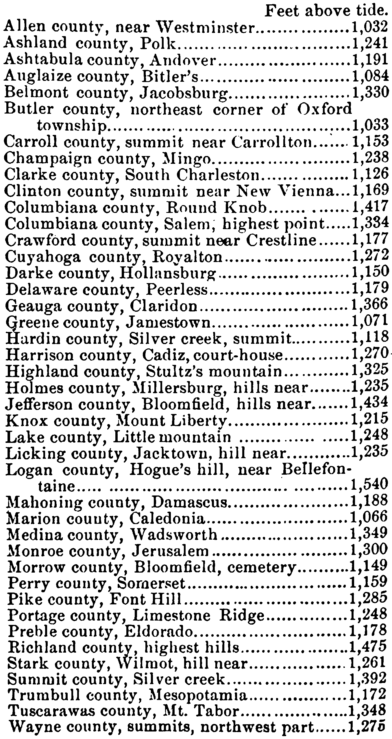
It is scarcely necessary to add that in almost every one of the counties named above the highest land of the State is or has been claimed by residents of these counties. The figures given in this table show the highest recorded elevations, but not necessarily the highest elevations. They can, however, be made to indicate by proper combination the highest-lying districts of the State.
The largest connected areas of high land extend from east to west across the central and northern central districts. In some limited regions of Central Ohio, especially along the ridge of high land just referred to, and also in a few thousand square miles of Northwestern Ohio, the natural drainage is somewhat sluggish, and, while the land is covered with its original forest growth, it inclines to swampy conditions; but when the forests are cleared away and the water courses are open most of it becomes arable and all of it can be made so without excessive outlay by means of open ditches.
The chief feature in the topography of Ohio is the main watershed which extends across the State from its northeastern corner to about the middle of its western boundary. It divides the surface of the State into two unequal slopes, the northern, which is much the smaller, sending its waters into Lake Erie and the Gulf of St. Lawrence, while the drainage of the other is directed to the Gulf of Mexico by the Ohio river. The average height of the watershed is about 1,100 feet above tide, but it is cut by three principal gaps, viz., those of the Tuscarawas, Scioto and Maumee rivers respectively. The elevation is reduced in these gaps to about 950 feet. They have been occupied by canals and railways for a number of years.
The watershed depends on two different lines of geological formation in different portions of the State, to the eastward on bedded rocks which rise in a low arch along the line that the watershed follows, and to the westward by enormous accumulations of glacial drift the maximum thickness of which is more than 500 feet.
Ohio owes but very little of the relief of its surface to folds of the rocks which underlie it. There are no pronounced anticlines or synclines in its structure. When successively lifted from the sea beneath which they were formed its several strata were approximately horizontal and also of approximately the same elevation. The present relief of the State is mainly due to erosive agencies. The original plain has been carved and dissected into complicated patterns during the protracted ages in which it has been worn away by rains and rivulets and rivers. Comparatively little of it now remains. In each, river system there is one main furrow that is deepened and widened as it advances, and tributary to the main furrow are countless narrower and shallower valleys which in turn are fed by a like system of smaller troughs. Most of the streams have their main valleys directed through their entire extent to either the north or the south, adapting themselves thus to the two main slopes of the State, but occasionally a considerable stream will for a score or more miles undertake to make its way against the general slope. A sluggish flow necessarily characterizes such streams. Examples are found in Wills creek, a tributary of the Muskingum, and in Connotton creek, which flows into the Tuscarawas river.
Fragments of the old plain still remain in the isolated “hills” or table-lands that bound the valleys and which, though often separated by intervals of miles, still answer to each other with perfect correspondence of altitude and stratification. They often occur in narrow and isolated serpentine ridges between the streams. These high lands rise to a maximum height of 600 leet above the rivers in the main valleys. Strictly speaking, there are no hills in Ohio, to say nothing of mountains, and there never have been any. The relief, as has been shown, results from valleys carved out of the original plain.
The glacial drift has had much to do in establishing the present topography, but its influence can be better stated at a later point in this review.
B.
GEOLOGY OF OHIO.
The geology of Ohio, though free from the obscurity and complications that are often met with in disturbed and mountainous regions, is still replete with scientific and economic interest. It has occupied the attention of students of this science for more than half a century, and during this time there have been a number of able men who have devoted many years of their lives to working out its problems. The State has also made large expenditures in carrying on geological investigations and in publishing the results of the same. It is still engaged in the work.
Previous to 1836, not much was known in regard to the age and order of the rock formations of the State. In fact, the science of geology was then but little advanced in any part of the country. Hon. Benjamin Tappan published a few notes pertaining to the coal fields of Ohio, in Silliman’s Journal (afterwards the American Journal of Science and Arts), between 1820 and 1830, and Caleb Atwater included in his archæological researches some geological observations. It was, however, to Dr. S. P. Hildreth, of Marietta, that we owe the first extended and connected accounts of the geology of any portions of our territory. His notes upon the salines or salt springs of the State and of the Ohio valley are full of interesting observations, but the account begun by him in the American Journal of Science and Arts in 1836 entitled “Observations on the Bituminous Coal Deposits of the valley of the Ohio, and the accompanying rock strata, with notices of the fossil organic remains and the relics of vegetable and animal bodies, illustrated by a geological map, by numerous drawings of plants and shells and by views of interesting scenery,” is decidedly the most comprehensive and important statement that had been made up to this time upon the geology of any part of the State. The descriptions and figures of fossils in this paper were made by Samuel George Morton, M. D., of Philadelphia.
It was in this year also that the first steps were taken by the legislature to determine the geological structure and resources of the State. A resolution was passed on the 14th day of March, 1836, providing for the appointment of a committee to report to the next legislature the best method of obtaining a complete geological survey of the State and the probable cost of the same. The committee consisted of Dr. S. P. Hildreth, chairman, Professors John Locke and J. H. Riddell and Mr. I. A. Lapham, all of whom were recognized as among the foremost students of geological science in the State.
The report of this committee was promptly made and, in accordance with its recommendations, a survey of the State was forthwith ordered (March 27, 1837). The first geological corps was organized as follows:
- Prof. W. W. Mather, State Geologist.
- Dr. S. P. Hildreth.
- Dr. John Locke.
- Prof. J. P. Kirtland.
- Col. J. W. Foster.
- Col. Chas. Whittlesley.
- Prof. C. Briggs, Jr.
The work of this survey was brought to an abrupt termination at the end of the second year of field work, the principal cause of discontinuance being the embarrassed condition of the State treasury, which in turn was owing to the financial panic of 1837. Though the duration of this survey was short, its results were of very great importance and value. A solid foundation had been laid on which observations could be intelligently carried on in every portion of the State. Several of the members of the old corps, and prominent among them, Col. Charles Whittlesley, maintained not only their interest, but their field work as well, though in a fragmentary and disconnected way, and from year to year work was done which could finally be utilized in a more thorough study of the subject. We owe very much to the members of this corps for their contributions to our knowledge of Ohio geology.
The second survey was ordered by the legislature in 1869, and there was fortunately placed at the head of it Professor J. S. Newberry, LL. D., widely recognized as the ablest geologist that Ohio has yet produced. Dr. Newberry brought to his task the results of many years of study of the structure of Ohio and also a wide experience in other fields. To his sagacity in interpreting both the stratigraphical and paleontological record of the State, science is under great obligations. The assistant geologists appointed with Dr. Newberry were Prof. E. B. Andrews, Prof. Edward Orton and Mr. J. H. Klippart. Prof. T. G. Wormley was appointed chemist of the survey. Active work on the survey was discontinued at the end of five years from the date of beginning, but the publication of results was kept up for a much longer time. In fact, some of the results of Dr. Newberry’s work are yet unpublished. Two reports of progress, 1869 and 1870, and four volumes of Geology are the published results of this survey. Two of these volumes are double, the second parts being devoted to paleontology (Vols. I. and IL).
In 1881 the survey was again revived, under the direction of Prof. Edward Orton, with special reference to the completion of the work in economic geology. Two volumes, viz., vols. V. and VI., have been already issued in this series. Prof. N. W. Lord was appointed chemist to the survey under the reorganization, and has done all of the work in this important department.
I. Geological Scale.
A brief review of the scale and structure of the State will here be given, but before it is entered upon, a few fundamental facts pertaining to the subject will be stated.
1. So far as its exposed rock series is concerned, Ohio is built throughout its whole extent of stratified deposits or, in other words, of beds of clay, sand and limestone, in all their various gradations, that were deposited or that grew in water. There are in the Ohio series no igneous nor metamorphic rocks whatever; that is, no rocks that have assumed their present form and condition from a molten state or that, subsequent to their original formation, have been transformed by heat. The only qualification which this statement needs pertains to the beds of drift by which a large portion of the State is covered. These drift beds contain bowlders in large amount, derived from the igneous and metamorphic rocks that are found around the shores of Lakes Superior and Huron, but these bowlders are recognized by all, even by the least observant, as foreign to the Ohio scale. They are familiarly known as “lost rocks” or “erratics.”
If we should descend deep enough below the surface we should exhaust these stratified deposits and come to the granite foundations of the continent which constitute the surface rocks in parts of Canada, New England and the West, but the drill has never yet hewed its way down to these firm and massive beds within our boundaries.
The rocks that constitute the present surface of Ohio were all formed in water, and none of them have been modified and masked by the action of high temperatures. They remain in substantially the same condition in which they were formed.
2. With the exception of the coal seams and a few beds associated with them and of the drift deposits, all the formations of Ohio grew in the sea. There are no lake or river deposits among them, but by countless and infallible signs they testify to a marine origin. The remnants of life which they contain, often in the greatest abundance, are decisive as to this point.
3. The sea in which or around which they grew was the former extension of the Gulf of Mexico. When the rocks of Ohio were in process of formation, the warm waters and genial climate of the Gulf extended without interruption to the borders of the great lakes. All of these rocks had their origin under such conditions.
4. The rocks of Ohio constitute an orderly series. They occur in widespread sheets, the lowermost of which are co-extensive with the limits of the State. As we ascend in the scale, the strata constantly occupy smaller areas, but the last series of deposits, viz., those of the Carboniferous period, are still found to cover at least one-fourth of the entire area of the State. Some of these formations can be followed into and across adjacent States, in apparently unbroken continuity.
The edges of the successive deposits in the Ohio series are exposed in innumerable natural sections, so that their true order can generally be determined with certainty and ease.
5. For the accumulation and growth of this great series of deposits, vast periods of time are required. Many millions of years must be used in any rational explanation of their origin and history. All of the stages of this history have practically unlimited amounts of past time upon which to draw. They have all gone forward on so large a scale, so far as time is concerned, that the few thousand years of human history would not make an appreciable factor in any of them. In other words, five thousand years or ten thousand years make too small a period to be counted in the formation of coal, for example, or in the accumulation of petroleum, or in the shaping of the surface of the State through the agencies of erosion.
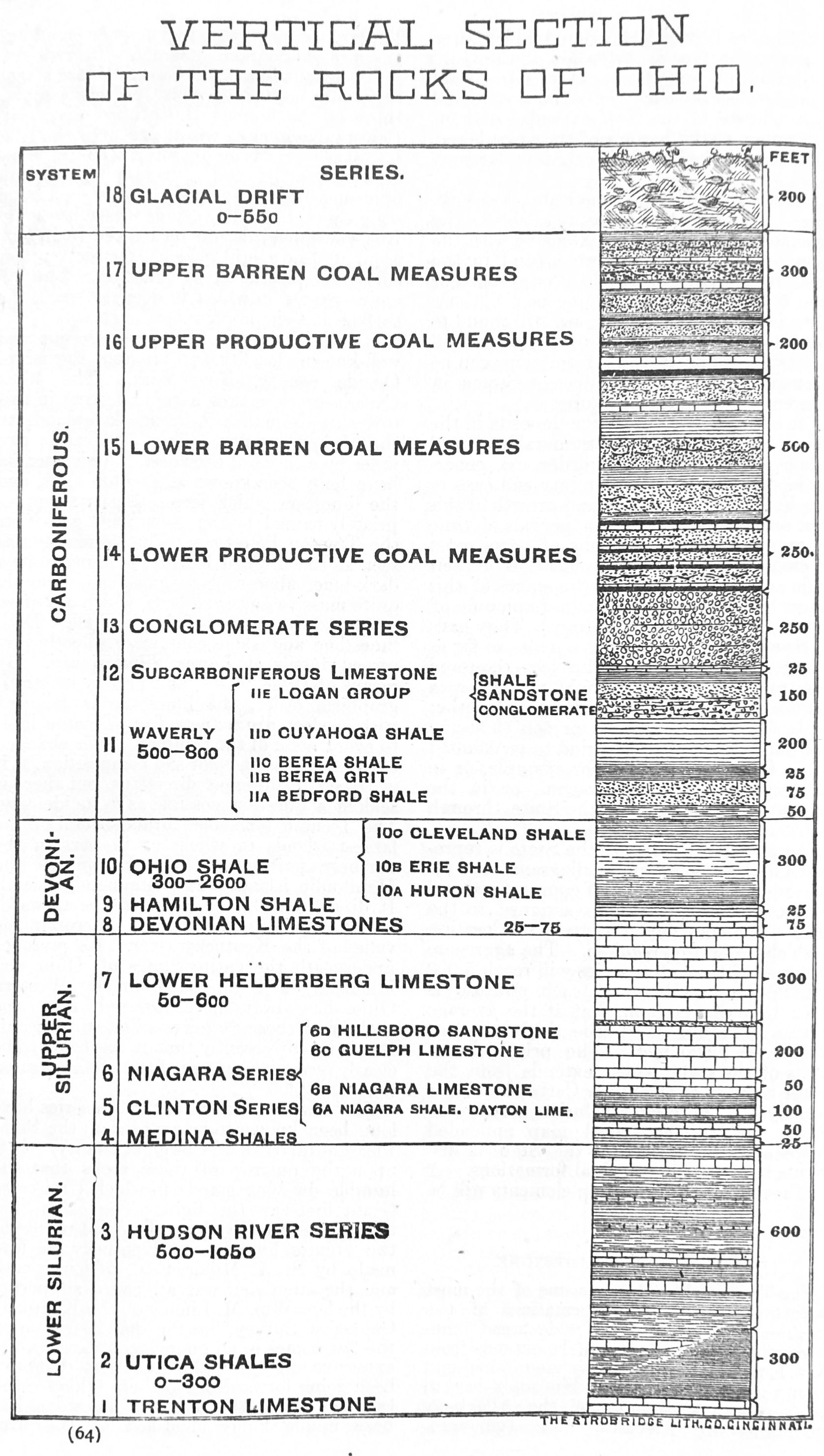
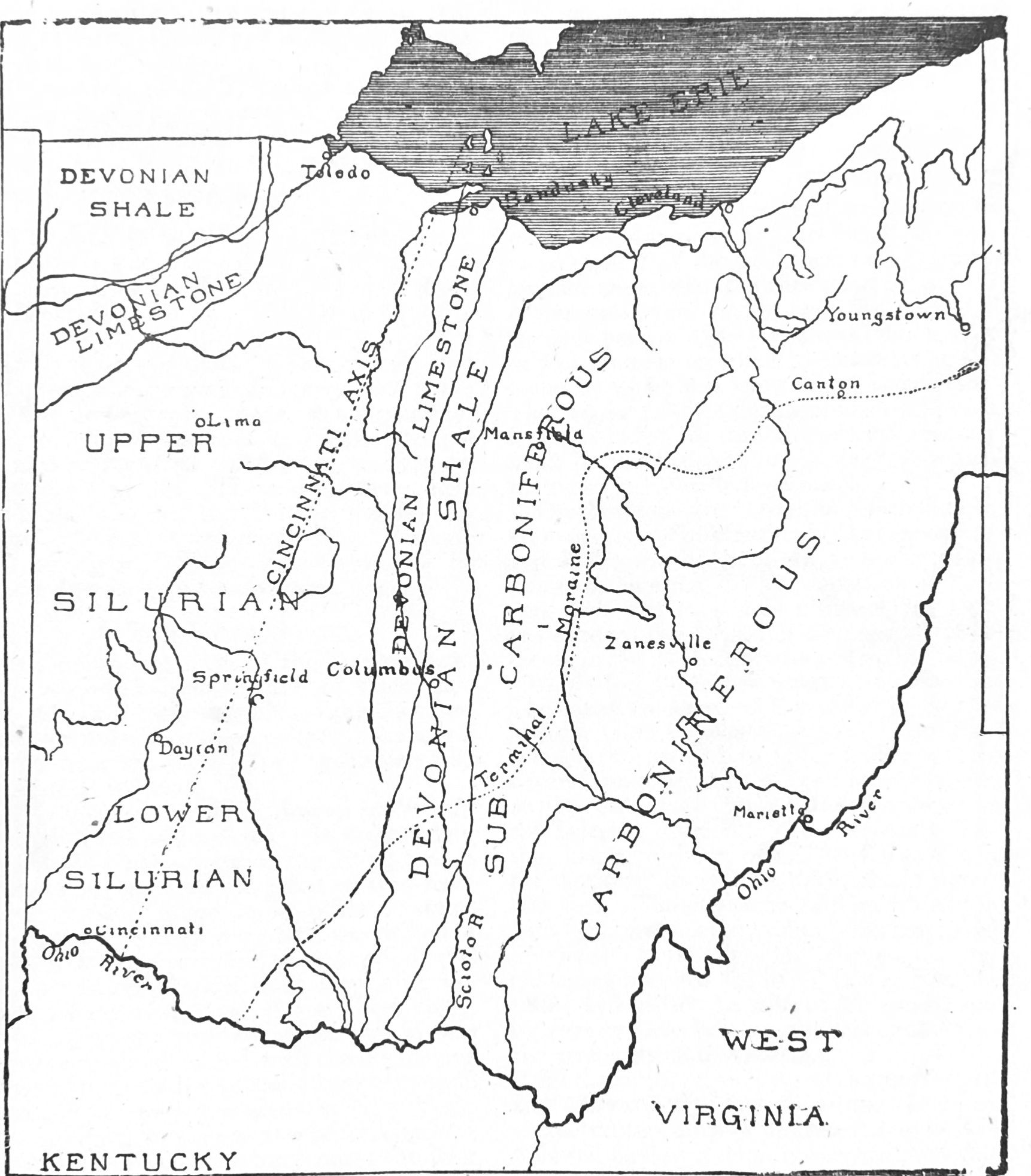
The geological scale of the State is represented in the accompanying diagram (page 6). The order of the series is, of course, fixed and definite, but the thickness assigned to the several elements depends upon the location at which the section is taken. The aggregate thickness of the entire series will reach 5,000 feet, if the maximum of each stratum is taken into the account, but if the average measurements are used, the thickness does not exceed 3,500 feet. The principal elements of the scale, which extends from the Lower Silurian to the upper Carboniferous or possibly the Permian, inclusive, are given below, and the geological map appended shows how the surface of the State is distributed among the principal formations. A brief review of these leading elements will be given at this point.
1. The Trenton Limestone.
The Trenton limestone is one of the most important of the older formations of the continent. It is the first widespread limestone of the general scale. It extends from New England to the Rocky mountains, and from the islands north of Hudson’s bay to the southern extremity of the Allegheny mountains in Alabama and Tennessee.
Throughout this vast region it is found exposed in innumerable outcrops. It gives rise as it decays to limestone soils which are sometimes of remarkable fertility, as, for example, those of the famous Blue Grass region of Central Kentucky, which are derived from it. It is worked for building stone in hundred of quarries, and it is also burned into lime and broken into road metal on a large scale throughout the regions where it occurs. But widespread as are its exposures in outcrop, it has a still wider extension under cover. It is known to make the floor of entire States in which it does not reach the surface at a single point.
It takes its name from a picturesque and well-known locality in Trenton township, Oneida county, New York. The West Canada creek makes a rapid descent in this township from the Adirondack uplands to the Mohawk valley, falling 300 feet in two miles by a series of cascades. These cascades have long been known as Trenton Falls, and the limestone which forms them was appropriately named by the New York geologists the Trenton limestone. The formation, as seen at the original locality, is found to be a dark-blue, almost black limestone, lying in quite massive and even beds, which are often separated by layers of black shale. Both limestone and shale contain excellently preserved fossils of Lower Silurian age. By means of these fossils, and also by its stratigraphical order, the limestone is followed with perfect distinctness from Trenton Falls to every point of the compass. It is changed to some extent, in color and composition, as it is traced in different directions, but there is seldom a question possible as to its identity. The Trenton limestone forms several of the largest islands in whole or in part in the northern portion of Lake Huron, as the Manitoulin islands and Drummond’s island. It dips from this region to the southward, but it is found rising again in outcrop in the valley of the Kentucky river. Its presence underneath the entire States of Ohio and Michigan, and especially under Western Ohio, has always been inferred, since the geology of these States was first worked out. But it is only recently that it has come to be clearly recognized as one of the surface formations of Ohio.
The lowest rocks in the State series have long been known to be exposed in the Point Pleasant quarries of Clermont county. It is upon the outcrop of these rocks that the humble dwelling stands in which Ulysses S. Grant first saw the light. The claim that these beds in reality belong to and represent the Trenton limestone of Kentucky was first made by S. A. Miller, Esq., of Cincinnati, and the same view was afterward supported by the late Wm. M. Linney of the Kentucky Geological Survey, but the demonstration of the fact comes in an unexpected way. In the extensive underground explorations that have been going forward in Northern Ohio for the last tew years, the Trenton limestone has been unmistakably identified as the firm limestone that is found at a depth of 1,000 to 2,000 feet below the surface, invariably covered with about 300 feet of black shale, containing the most characteristic fossils of the Utica shale. As this limestone has been followed southward, it has been found steadily rising, coming gradually nearer to the surface, and the rate has been found to be such from the nearest determination that it would correspond very well with the formation that crops out in the Ohio valley at Point Pleasant.
As seen there the Trenton limestone is a light or grayish-blue limestone, quite crystalline in structure, massive in its bedding, and fossiliferous. Its general composition is as follows:
- Carbonate of lime, 75 to 85 %
- Carbonate of magnesia, 1 to 5 %
- Alumina and oxide of iron, 2 to 8 %
- Insoluble residue, 10 to 15 %
It is not, in this phase, a porous rock.
The most surprising discovery ever made in Ohio geology comes from this formation. In 1884 it was found to be at Findlay a source of high pressure gas and later a great repository of petroleum. These discoveries have made the name of the Trenton limestone a household word throughout Ohio, Indiana and Michigan. These discoveries will be briefly described on a subsequent page.
2. The Utica Shale.
The immediate cover of the Trenton limestone is a well-known stratum of black shale 300 feet in thickness, which, from its abundant outcrops in the vicinity of Utica, received from the New York geologists the name of Utica shale.
This stratum has been proved to be very persistent and widespread. It is sparingly fossiliferous, but several of the forms that it contains are characteristic, that is, they have thus far been found in no other stratum. The first of the deep wells that was drilled in 1884 in Findlay revealed, at a depth of 800 feet, a stratum of black shale containing the most characteristic fossil of the Utica shale, viz., Leptobolus insignis Hall, and it was thus positively identified with the last-named formation. This bed of shale has the normal thickness of the Utica shale in New York, viz., 300 feet, and with the other elements involved, it extended and continued the New York series into Northern Ohio in a most unexpected and, at the same time, in a most satisfactory way.
The Utica shale, thus discovered and defined, is a constant element in the deep wells of Northwestern Ohio. Its upper boundary is not always distinct, as the Hudson river shale that overlies it sometimes graduates into it in color and appearance; but as a rule the driller, without any geological prepossessions whatever, will divide the well section in his record so as to show about 300 feet of black shale at the bottom of the column or immediately overlying the Trenton limestone. This stratum holds its own as far as the southern central counties. In the wells of Springfield, Urbana and Piqua it is found in undiminished thickness, but apparently somewhat more calcareous in composition. From these points southward the black shale thins rapidly. It is apparently replaced by dark-colored limestone bands known as pepper and salt rock by the driller.
From these and similar facts it appears that the Utica shale is much reduced and altered as it approaches the Ohio valley, and is finally lost by overlap of the Hudson river shale in this portion of the State and to the southward.
3. The Hudson River Group.
The very important and interesting series now to be described appears in all the previous reports of the geological survey under another name, viz., the Cincinnati group. It is unnecessary to review here the long discussions pertaining to the age of this series, or the grounds on which the changes in the name by which it is known have been based. The return to the older name here proposed is necessitated by the discoveries recently made in our underground geology, to which reference has already been made.
The Hudson river group in Southwestern Ohio consists of alternating beds of limestone and shale, the latter of which is commonly known as blue clay. The proportion of lime and shale vary greatly in different parts of the series. The largest percentage of shale occurs in the 250 feet of the series that begin 50 or 75 feet above low water at Cincinnati. The entire thickness of the series in Southwestern Ohio is about 750 feet. The division of the series into lower and upper is natural and serviceable. The lower is known as the Cincinnati division and the upper as the Lebanon division. The Cincinnati division has a thickness of 425 to 450 feet, and the Lebanon division a thickness of about 300 feet. The divisions are separated on both paleontological and stratigraphical grounds. Both divisions abound in exquisitely preserved fossils of Lower Silurian time; and in fact the hills of Cincinnati and its vicinity have become classical grounds to the geologists on this account.
As the series takes cover to the northward and eastward it retains for a time the same characteristics already described, but as it is followed farther it rapidly becomes less calcareous. The limestone courses are thinner and fewer, and the entire series comes to be counted shale.
The Hudson river group occupies in its outcrop about 4,000 square miles in Southwestern Ohio, but it is doubtless coextensive with the limits of the State. The shales of the series contain in outcrop large quantities of phosphates and alkalies, and the soils to which they give rise are proverbial for their fertility.
The presence of these fine-grained and impervious shales in so many separate beds forbids the descent of water through the formation. In its outcrop the formation has no water supply, and, as found by the driller, it is always dry. It gives rise to frequent “blowers” or short-lived accumulations of high-pressure gas when struck by the drill, as has been found in the experience in many towns of Western Ohio within the last two years, and it also yields considerable amounts of low-pressure shale gas which proves fairly durable.
4. The Medina Shale.
A stratum of non-fossiliferous shale, often red or yellow in color and having a thickness of ten to forty feet, directly overlies the uppermost beds of the Hudson river group at many points in Southwestern Ohio. The occurrence of 50 to 150 feet of red shale in most of the recent deep borings in Northwestern Ohio at exactly the place in the general column where the Medina should be, and so much nearer to the known outcrops of the formation that its continuity with these was hardly to be questioned, this fact, taken in connection with the occurrence of like beds of red shale holding the same relative position in several deep borings in the central portions of the State, serves to give warrant for counting the Medina epoch duly represented in the outcropping strata of Southwestern Ohio. It occurs here only in included sections, its thin and easily eroded beds never being found as surface formations for extensive areas. There is good reason to believe that the Medina formation is coextensive with the limits of the State, except in the regions from which it has already been removed.
5. The Clinton Limestone.
The Clinton group of New York appears as a surface formation in Ohio only id the area already named. It forms a fringe or margin of the Cincinnati group through eight or ten counties, rising above the soft and easily eroded rocks of this series, and of the previously named Medina shale, in a conspicuous terrace. It is everywhere a well-characterized limestone stratum. It is highly crystalline in structure, and is susceptible of a good polish. In some localities it is known as a marble. A considerable part of it, and especially the upper beds, are almost wholly made up of crinoidal fragments. In thickness it ranges between ten and fifty feet. Its prevailing colors are white, pink, red, yellow, gray and blue. At a few points it is replaced by the hematite ore that is elsewhere so characteristic of the formation. The ore in Ohio is generally too lean and uncertain to possess economic value, but it was once worked for a short time and in a very small way in a furnace near Wilmington, Clinton county.
The limestone contains a notable quantity of indigenous petroleum throughout most of its outcrop, but no very valuable accumulations of oil or gas have been found in it thus far. It is the source of the low-pressure gas of Fremont (upper vein), and also of the gas at Lancaster from 1,962 feet below the surface, and at Newark from 2,100 feet below the surface. In fact, a small but fairly persistent flow is maintained from this horizon in several of the gas-producing dis, tricks of Northern Ohio. In a single instance in Wood county it is proving itself an oil rock. A well near Trombley, drilled to this horizon, has been flowing twenty to thirty barrels of oil for a number of months, the oil being referable to this formation.
In outcrop the stratum is quite porous as a rule, and the water that falls upon its uncovered portions sinks rapidly through them to the underlying shale (Medina), by which it is turned out in a well-marked line of springs.
In composition, the limestone, in its outcrops in Southern Ohio, is fairly constant. All of its most characteristic portions contain eighty to eighty-five per cent. of carbonate of lime, and ten to fifteen percent, of carbonate of magnesia. At a few points, however, it is found as the purest carbonate of lime in the State. Under cover, to the northward, it is much more magnesian in composition, being indistinguishable from the Niagara. It also becomes shaly and changeable in character at many points. As it becomes shaly the thickness is much increased.
It is everywhere uneven in its bedding, being in striking contrast in this respect with the formations below it and also above it. The beds are all lenticular in shape, and they extend but a few feet in any direction. They seldom rise to one foot in thickness.
The uneven bedding, the crystalline and crinoidal characters, the high colors, and particularly the red bands and the chemical composition, combine to make the Clinton limestone an exceedingly well-marked stratum throughout Southwestern Ohio, and from the hints yielded by the drill in Northwestern Ohio, it seems to have something of the same character there, especially so far as color is concerned. It becomes more shaly and much thicker to the eastward. It carries bands of red shale almost universally throughout the northern central and central parts of the State.
The limestone is directly followed at a number of points in the territory occupied by it by a stratum of very fine-grained, bluish-white clay, containing many fossils distributed through it, the fossils being crystalline and apparently pure carbonate of lime. A similar bed of white clay is reported at the same horizon, by the drillers in Northern Ohio, and the drillings show the presence of fossils of the same characters. This clay seam can be designated the Clinton clay, but it merges in and is indistinguishable from the lowest element in the next group. The Clinton, in its outcrops, is entirely confined to Southern Ohio.
6. The Niagara Group.
The Clinton limestone is followed in ascending order by the Niagara group, a series of shales and limestones that has considerable thickness in its outcrops and that occupies about 3,000 square miles of territory in Ohio. The lowest member is the Niagara shale, a mass of light-colored clays, with many thin calcareous bands. It has a thickness of 100 feet in Adams county, but it is reduced rapidly as it is followed northward, and in Clarke and Montgomery counties it is not more than ten or fifteen feet thick. Still further to the northward, as appears from the records of recent drillings, the shale sometimes disappears entirely, nut in the great majority of wells, especially in Hancock and Wood counties, it is a constant element, ranging from five to thirty feet. Wells are often cased in this shale, but a risk is always taken in doing so.
In Montgomery, Miami and Greene counties the shale contains in places a very valuable building-stone, which is widely known as the Dayton stone. It is a highly crystalline, compact and strong stone, lying in even beds of various thickness, and is in every way adapted to the highest architectural uses. It carries about ninety-two per cent. of carbonate of lime. The Niagara shale is, as a rule, quite poor in fossils. It is apparently destitute of them in many of its exposures.
The limestone that succeeds the shale is an even-bedded, blue or drab, magnesian stone, well adapted at many points to quarrying purposes. It is known in Ohio by various local names, derived from the points where it is worked. There are several subdivisions of it that are unequally developed in different portions of the State. Like the shale below it, this member is thickest in Southern Ohio. It cannot be recognized as a distinct element in the northern part of the State, either in outcrop or in drillings. It may be that its horizon is not reached in any natural exposures of the formation in this part of the State.
The uppermost division of the formation is the Guelph limestone, which differs very noticeably in several points from the Niagara limestone proper. It obtains its name from a locality in Canada, where it was first studied and described. It has a maximum thickness in Southern Ohio of 200 feet. It differs from the underlying limestone in structure, composition, and fossils. It is either massive or very thin-bedded, rarely furnishing a building stone. It is porous to an unusual extent. It is generally very light in color, and is everywhere in the State nearly a typical dolomite in composition. It yields lime of great excellence for the mason’s use.
Unlike the previously named divisions of the Niagara, the Guelph limestone is as well developed in Northern as in Southern Ohio in all respects. Not more than forty feet are found in its outcrops here, but the drill has shown several times this amount of Niagara limestone, without giving us all of the data needed for referring the beds traversed to their proper subdivisions. What facts there are seem to point to the Guelph as the main element in this underground development of the formation in this portion of the State.
The Hillsboro sandstone is the last element in the Niagara group. It is found in but few localities, and its reference to the Niagara series in its entirety is not beyond question. In Highland county it has a thickness of thirty feet in several sections. It is composed of very pure, even-grained, sharp silicious sand. Other deposits of precisely the same character are found in the two next higher limestones of the scale at several points in the State.
The Hillsboro sandstone is sometimes built up above all the beds of the upper Niagara limestone, but again, it is, at times, interstratified with the beds of the Guelph division. In the latter case it is itself fossiliferous, but when found alone it seems destitute of all traces of life. These sandstones in the limestone formations suggest in their peculiarities a common origin. They consist of unworn and nearly perfect crystals, in considerable part.
The Salina group has appeared in all the recent sections of the rocks of the State, but in the light of facts obtained within the latest explorations, it can no longer be counted a distinct or recognizable element in the Ohio scale.
7. The Lower Helderberg or Waterlime Formation.
The interval that exists between the Niagara and the Devonian limestones is occupied in Ohio by a very important formation. It is filled with a series of beds, which are in part, at least, the equivalents of the Waterlime of New York.
The name is unhappily chosen. Strictly applicable to only an insignificant fraction of the beds of this series in New York, we are still obliged to apply the designation Waterlime, with its misleading suggestions, to all deposits of the same age throughout the country.
Though the last to be recognized of our several limestone formations, the Waterlime occupies a larger area in Ohio than any other, its principal developments being found in the drift-covered plains of the northwestern quarter of the State. It has also a much greater thickness than any other limestone, its full measure being at least 600 feet, or twice the greatest thickness of the Niagara limestone.
It can be described as, in the main, a strong, compact, magnesian limestone, poor in fossils, and often altogether destitute of them for considerable areas, microscopic forms being excepted. It is, for the most part, drab or brown in color; but occasionally it becomes very light-colored, and again it is often dark blue. It is brecciated throughout much of its extent, the beds seeming to have been broken into sometimes small and sometimes large angular fragments after their hardening, and then to have been re-cemented without further disturbance. In addition to this, it contains an immense amount of true conglomerate, the pebbles, many of which are bowlders rather than pebbles, being all derived from the rocks of the same general age. The surface of many successive layers at numerous points are covered with sun-cracks, thus furnishing proof of having been formed in shallow water near the edge of the sea. In such localities the beds are usually quite thin, and are also impure in composition. In these respects it suggests the conditions of the Onondaga salt group of New York. These features are very characteristic ones. A rude concretional structure is also quite distinctive of the beds of this age. The Waterlime in Ohio everywhere contains petroleum in small quantity, which is shown by the odor of freshly broken surfaces. No noteworthy accumulations of oil or gas have thus far been found within it. At some points it carries considerable asphalt, distributed through the rock in shot-like grains, or in sheets and films. Thin streaks of carbonaceous matter traversing the rock parallel to its bed-planes are one of the constant marks of the stratum in Ohio. It is generally thin and even in its bedding; but in some localities it contains massive beds. At some points it is remarkable for its evenness, and great value is given to the formation on this account, when combined with other qualities already named. It is frequently a nearly pure dolomite in composition, and accordingly it yields magnesian lime of high quality and is extensively burned in the State, rivaling in this respect the Guelph beds of the Niagara.
In Southern Ohio it has a maximum thickness of 100 feet, and here it reaches its highest quality in all respects; but in Central and Northern Ohio it attains the great thickness previously reported. There also it contains several distinct types of limestone rock. A considerable part of it is very tough, strong, dark-blue limestone, while other portions are white, porous, and soft.
Its fossils are referable, in type at least, to the age of the Waterlime, as already stated. The most characteristic forms are the crustacean named Eurypterus. which was found by Newberry on the islands of Lake Erie, and which has not been reported elsewhere in the State; and the bivalve crustacean Leperditia. There are points in the State, however, where the stratum contains a considerable fauna, and perhaps ground may be found for removing some of the higher beds that are now included in it into a distinct division, viz., the Shaly limestone of the Lower Helderberg series. Greenfield, Highland county, and Lima may be named as localities near which especially fossiliferous phases of the Waterlime can be found.
The Sylvania Sandstone.
A remarkable series of deposits of extremely pure glass sand has long been known in Lucas and Wood counties of Northern Ohio. The best known beds are those of Sylvania and Monclova, northwest and southwest of Toledo.
The Sylvania sandstone has been hitherto referred to the Oriskany period, but a careful study of the section in which it is included renders this reference inadmissible. Its position is about 150 feet below the Upper Helderberg limestone or somewhat above the middle line of the Lower Helderberg division.
8. The Upper Helderberg Limestones.
All of the limestone of Devonian age in Ohio has been generally referred to the Corniferous limestone of New York, but on some accounts the more comprehensive term used above is counted preferable. A two-fold division of the series is possible and proper in Ohio, the division being based on both lithology aud fossils. The divisions are known as the lower and upper, respectively, or as the Columbus and Delaware limestones. The upper division is sometimes called the Sandusky limestone. The maximum thickness of the entire series in Ohio is seventy-five to one hundred feet.
In chemical composition, the Corniferous limestone is easily distinguishable from all that underlie it. It is never a true dolomite in composition, as the Waterlime and Niagara limestones almost always are. The composition of the typical, heavy-bedded lower Corniferous may be taken as seventy per cent. carbonate of lime and twenty-five per cent. carbonate of magnesia. The higher beds of the Columbus stone regularly yield ninety-one to ninety-five per cent. carbonate of lime. The upper division, or the Delaware stone, is much less pure in Central Ohio than the lower, a notable percentage of iron and alumina, as well as silica, generally being contained in it It is, therefore, seldom or never burned into lime. In Northern Ohio, on the contrary, it is often found very strong and pure limestone.
Both divisions, but particularly the lower one, carry occasional courses of chert, that detract from the value of the beds in which they occur. The chert is found in nodules which are easily detached from the limestone for the most part. In some conditions in which the chert occurs, fossils are found in it in a remarkably good state of preservation.
Throughout the entire formation Devonian fossils abound in great variety and in great numbers. They are often found in an excellent state of preservation. The oldest vertebrate remains of the Ohio rocks are found in the Corniferous limestone, a fact which gives especial interest to it. The uppermost bed of the lower or Columbus division is, in many places, a genuine “bone bed;” the teeth and plates and spines of ancient fishes, largely of the nearly extinct family of ganoids, constituting a considerable portion of the substance of the rock. Corals of various types are also especially abundant and interesting in this limestone. In fact, the formation is the most prolific in life of any in the Ohio scale.
With this formation the great limestones of Ohio were completed. While they are built into the foundations of almost the entire State, they constitute the surface rocks only in its western half. The Upper Silurian and Devonian limestones of our scale, which were formerly known as the Cliff limestone have an aggregate thickness of 750 to 1,150 feet where found under cover, and though differences exist among them by which, as has already been shown, they can be divided into four or more main divisions, there is still no reason to believe that any marked change occurred in the character of the seas during the protracted periods in which they were growing. The life which these seas contained was slowly changing from age to age, so that we can recognize three or more distinct faunas or assemblages of animal life in them. Differences are also indicated in the several strata as to the depth of the water in which they were formed, and as to the conditions under which the sedimentary matter that enters into them was supplied, but no marked physical break occurs in the long history. No part of the entire series indicates more genial conditions of growth than those which the Devonian limestone, the latest in order of them all, shows. It is the purest limestone of Ohio. Foot after foot of the formation consists almost exclusively of the beautifully preserved fragments of the life of these ancient seas. In particular the corals and crinoids that make a large element in many of its beds could only have grown in shallow but clear water of tropical warmth.
The change from the calcareous beds of this age to the next succeeding formation is very abrupt and well marked, as much so, indeed, as any change in the Ohio scale.
10. The Ohio Shale.
(Cleveland Shale, Erie Shale, Huron Shale.)
A stratum of shale, several hundred feet in thickness, mainly black or dark-brown in color, containing, especially in its lower portions, a great number of large and remarkably symmetrical calcareous and ferruginous concretions, and stretching entirely across the State from the Ohio valley to the shores of Lake Erie, with an outcrop ranging in breadth between ten and twenty miles, has been one of the most conspicuous and well-known features of Ohio geology since this subject first began to be studied. It separates the great limestone series already described, which constitutes the floor of all of Western Ohio, from the Berea grit, which is the first sandstone to be reached in ascending the geological scale of the State.
This great series of shales was formerly divided into three divisions, as indicated above, but a larger knowledge of the system makes it apparent that no definite boundaries can be drawn through the formation at large. The lower part is chiefly black, the middle contains many light colored bands and the upper beds again are often dark, but the sections obtained from top to bottom in the drilling of deep wells at various points in the State show alternations of dark and light colored bands not once but scores of times. The three-fold division formerly made is not only unsupported, but is misleading and objectionable. The terms are used to cover different phases of one and the same formation.
The mineral basis of all these shales, whether black, brown, blue, gray or red, is essentially one and the same thing, viz., a fine-grained clay, derived from the waste of distant land. As supplied to the sea basin it was originally blue or gray, but a small percentage of peroxide of iron goes a great way in coloring such deposits red, and in like manner, organic matter in comparatively small amount gives them a dark or black color. The organic matter that colors these shales was probably derived in large part, as Newberry has suggested, from the products of growth and decay of sea-weeds by which these seas were covered, like the Sargasso seas of our own day.
These organic matters seem to have accumulated along the shores and in shallow water in greater quantity than in the deeper seas. Hence, if the section of these shale deposits is taken near the old shore-lines, or where shallow water occurred, a larger proportion is black than if the more central areas are examined. The only land of Ohio at this time was to be found in and along the Cincinnati axis, a low fold that had entered the State from the southward at the close of Lower Silurian time, and that had been slowly extending itself northwards through the succeeding ages. Southwestern Ohio was already above water, a low island in the ancient gulf. But the shales on their western outcrop, where they are largely black, are exactly equivalent in age to the alternating beds of black and blue shale, the latter being in large excess, that were forming at this time in the central parts of the basin, viz., in Eastern Ohio. The color of the shales is, in this view, an accident, and cannot be safely used as a ground of division. The entire shale formation that we are considering seems to have been laid down without physical break or interruption. It must have required an immensely long period for its accumulation. This is shown not only by the fineness and uniformity of the materials which compose it, and which could not have been rapidly supplied, and by the great thickness of the formation in Eastern Ohio, but also by the geological equivalents of the shale in the general column which furnish even more convincing proof as to its long continued growth. The Ohio shale, as Newberry has shown, is certainly the equivalent in the general scale of the Genesee slate, the Portage group and the Chemung group, the last named being itself a formation of great thickness and extent. In other words, the shales of our column bridge the interval between the Hamilton proper and the Catskill group, and in the judgment of some geologists, a wider interval even than that named above. As Newberry was the first to show, the oil sands of Pennsylvania are banks of pebble rock that are buried in the eastern extension of the Ohio shale, but which make no sign within our own limits.
The shales are, for the most part, poor in fossils, except in those of microscopic size hut among the few that they contain are the most striking and remarkable not only of the scale of Ohio, but of all Devonian time as well. Reference is here made to the great fishes which have been described by Newberry and which constitute so interesting a chapter of geological history. Some of them belong to the basal beds of the shale formation, and others near the summit. The first were found at the centres of the great concretions already named as characteristic of the formation. These fossils are interesting both on account of their enormous size ana of their peculiar combination of points of structure that are widely separated now.
Brief mention must be made of the vegetable fossils of the shales.
Fossil wood, derived from ancient pine trees of the genus Dadoxylon, is quite common in the lower beds (Huron). The wood is silicified and the original structure is admirably preserved. This wood is sometimes found, like the fish remains already noted, at the hearts of the concretions, but occasionally large sized blocks are found free in the shale. On account of its enduring nature it is often found in those beds of glacial drift that have been derived largely from the destruction of the shales.
Strap-shaped leaves, presumably of sea-weeds, are occasionally found upon the surfaces of the shale layers. Sometimes they form thin layers of bright coal which deceive the ignorant Fossil rushes, of the genus Calamites, are also occasionally met with.
But the forms already named are of small account, so far as quantity is concerned, when compared with certain microscopic fossils that are, with little doubt, of vegetable origin, and which are accumulated in targe amount throughout the black beds of the entire shale formation, composing, sometimes, a notable percentage of the substance of the rock, and apparently giving origin, to an important extent, to the bituminous character of the beds.
The leading forms of these microscopic fossils are translucent, resinous discs, ranging in long diameter from one-thirtieth to one-two-hundredth of an inch. Several varieties have already been noted, depending on the size, particular shape and surface markings of these bodies. The facts pertaining to them have of late been more widely published, and the attention of geologists in various parts of the world has been called to these ana simitar forms, and thus there is the promise of a speedy enlargement of our knowledge in regard to them. Sir William Dawson now considers the comm on forms to be the macrospores of rhizocarps allied to Salvinia of the present day. The sporocarps containing these macrospores in place have recently been discovered. This identification would refer these bodies to floating vegetation on the surface of the seas in which the shales were formed, and is thus directly in line with the sagacious interpretation of Newberry, who many years ago attributed the origin of these black shales to Sargasso seas.
This shale is the undoubted source of most of the natural gas and petroleum of North, eastern Ohio. It is the probable source, under cover, of a considerable part of these highly valued substances in Western Pennsylvania. It gives rise to “surface indications of and oil throughout the whole extent of its outcrops and thus very often misleads explorers, since the indications do not stand in any case for large accumulations of either substance. The most that is to be expected of gas-wells in this formation is a domestic supply. A single well will furnish gas enough for the heat and light of one or more families and often the supply will be maintained for many years. In the parts of the State where the shales make the surface rocks, it will no doubt be found possible to secure from them valuable additions to our stores of light and heat for a long while to come. A farm in such territory will come to be valued on this account in something of the same way that it would be if it carried a seam of coal.
11. The Waverly Group.
The important mass of sediments of Subcarboniferous age, which is known in Ohio and in some adjoining States as the Waverly group, comes next in the column. The name Waverly was given to these strata by the geologists of the first survey, from the fact that at Waverly, in the Scioto valley, excellent sandstone quarries were opened in them, the products of which were quite widely distributed throughout Central and Southern Ohio, as far back as fifty years ago. Associated with the sandstone at this locality, and everywhere throughout the district, were several other strata that were always counted as members of the group by the geologists who gave the name. In fact, the boundaries were made definite and easily applicable. The Waverly group extended, by its definition and by unbroken usage in our early geology, from the top of the great black shale (Cleveland shale), to the Coal Measure conglomerate. This latter element was, in a part of the field, confused with the Waverly conglomerate, afterwards recognized and defined by Andrews, until a recent date, it is true, but the intent of the geologists is apparent, and many of their sections were complete and accurate. If the term Waverly is to be retained in our classification, and it bids fair to be, every interest will be served by recognizing and retaining the original boundaries.
11a. The Bedford Shale.
This stratum, which makes the base of the Waverly series, consists of forty to sixty feet, in the main composed of red or blue shales, but which sometimes contain fine-grained sandstone courses. The latter are in places valuable. They are represented by the Independence bluestone of Northern Ohio. The shales are mainly destitute of fossils, aside from the burrows of sea worms which are found on the surfaces of most of the layers and often with great sharpness of outline. All the layers are likely to be ripple-marked, the sculpturings of this sort being very symmetrical and continuous for layer after layer through many feet of the formation.
11b. The Berea Grit.
We have reached in our review the Berea grit, the second element of the Waverly series, and not only the most important member of the series, but by far the most important single stratum in the entire geological column of Ohio. Its economic value above ground is great, but it is greater below. In its outcrops it is a source of the finest building stone and the best grindstone grit of the country, and when it dips beneath the surface it becomes the repository of invaluable supplies of petroleum, gas, and salt-water. Its persistence as a stratum is phenomenal. Seldom reaching a thickness of fifty feet, its proved area in Ohio, above ground and below, is scarcely less than 15,000 square miles, and beyond the boundaries of Ohio it extends with continuity and strength unbroken into at least four other adjacent States. As a guide to the interpretation of our series, and especially as a guide in our subterranean geology, it is invaluable.
The stratum was named by Newberry from the village of Berea, Cuyahoga county, where the largest and most important quarries of the formation are located. The name is the most appropriate that could have been selected for this stratum, and inasmuch as it has priority in all fields, it ought to be made to supersede all others.
The Berea grit, as seen in outcrop, is a sandstone of medium grain in Northern Ohio, and of fine grain from the centre of the State southward. In Northern Ohio it contains one pebbly horizon over a considerable area, but the seam is thin and the pebbles are small. The stratum is sometimes false-bedded and sometimes remarkably even in its bedding-planes. Its main beds, or sheets, have a maximum thickness of six feet, but this is an unusual measure and is seldom reached. It ranges in thickness from 5 to 170 feet, and it very rarely fails altogether from the sections in which it is due.
Like the Bedford shale below it, it stands for an old shore-line, many of its surfaces being ripple-marked, and worm-burrows abounding in its substance.
It is poor in fossils, but not entirely destitute of them. It grows finer grained and more impure as it is followed southward. In Southern Ohio it is known as the Waverly quarry-stone.
The Berea grit is the lowest or main oil-sand of the Mackburg field. It is also the gas-rock of Wellsburg, and that part of the Ohio valley, and is without doubt one of the main oil- and gas-rocks of Western Pennsylvania.
11c. The Berea Shale.
A bed of dark or black shale, fifteen to fifty feet thick, makes the constant and immediate cover of the Berea grit throughout its entire extent in Ohio. The shale is highly fossiliferous, and is rich in bituminous matter, the amount sometimes reaching twenty per cent. It is a source of petroleum on a small scale, as is shown by the fact that in Southern Ohio an important ledge of sandstone that belongs just above it is often found saturated with a tar-like oil derived from this source. It was first recognized by Andrews, who described it under the name of the Waverly black shale. It constitutes an invaluable guide in our subterranean geology.
11d. The Cuyahoga Shale.
This formation consists of light-colored, argillaceous shales, which are often replaced with single courses of fine-grained sandstone, blue in color, and in Southern Ohio weathering to a brownish-yellow. As a constant characteristic, there are found through the shales flattened nodules of impure iron ore, concretionary in origin, and often having white calcareous centres.
In thickness it ranges from 150 to 400 feet. It is one of the most homogeneous and persistent formations in the column of the State throughout most of its extent. Everywhere through the State there is found at or near the base of this division a number of courses of fine-grained stone. These courses are sometimes separated from each other by beds of shale, or they may be compacted into a single stratum. The individual courses also vary greatly in thickness, and in color and general characters. Throughout Southern Ohio, and particularly in Ross, Pike, and Scioto counties, the stratum yields freestone. It is best known from its outcrops on the Ohio river at Buena Vista, where it has long been very extensively worked for Cincinnati and other river markets. The Buena Vista stone, at its best, is one of the finest building stones of the country. The same horizon yields excellent stone near Portsmouth, Lucasville, and Waverly. It is known as the Waverly brown stone at the latter point.
Northward, through the State, stone of more or less value is found in the bottom courses of the Cuyahoga, but in Trumbull county, near Warren, the horizon acquires extreme importance as the source of the finest natural flagging that is found in our markets.
It would have been well if the thirty or forty feet containing these courses had been cut off from the Cuyahoga shale, in which case the division thus formed would have been appropriately named the Buena Vista stone.
11e. The Logan Group.
(The Olive Shales of Read. The Logan Sandstone of Andrews. The Waverly Conglomerate of Andrews.)
The divisions of the Waverly series in Northern Ohio happened to be made at a point where the section is abnormal and incomplete. By atrophy or by overlap, the upper member of the series is wanting in the Cuyahoga valley, or is at least very inadequately represented there. The missing member is, in volume, second only to the Cuyahoga shale, among the divisions of the Waverly. It is much richer in the fossils of the Subcarboniferous than any of the other members. In composition it is varied and striking, one of its elements being a massive conglomerate not less than 200 feet in its largest sections, which extends in unbroken outcrop through at least a dozen counties of Ohio. No good reason can be found for dividing the Waverly series at all if a member like this is to be left without a name, or is to be merged with an unlike and incongruous division from which it is as sharply differentiated as any one stratum of Ohio is from any other.
The real, though not the formal, separation of this group from the underlying shale is due to the late Prof. E. B. Andrews, and constitutes one of his most important contributions to our knowledge of Ohio geology. He was the first to show that the great conglomerate of Hocking, Fairfield, and Licking counties is Subcarboniferous in age, and he further called attention to a highly fossiliferous, fine-grained sandstone overlying the conglomerate, to which he gave the name of Logan sandstone, from its occurrence at Logan, Hocking county. Up to this time this conglomerate had been universally counted as the Coal Measure conglomerate. Read made known the existence of a heavy body of shale, which he called Olive shales, overlying the conglomerate, and replacing the Logan sandstone in Knox, Holmes, and Richland counties.
As both conglomerate and sandstone have their typical outcrops at Logan, no better name can be found for the formation which must include conglomerate, sandstone, and shale, than that here adopted, viz., Logan group.
The maximum thickness of the Logan group is not less than 400 feet. Its average thickness is perhaps 200 feet.
A typical or representative section of this group is scarcely possible, but the most characteristic and persistent part of the series is the conglomerate that is found at the bottom. At all events, coarse rock, if not always technically conglomerate, is generally found here. Pebbles do not make a conspicuous part of the rock when it takes a conglomeritic phase in all cases. The most characteristic feature of the pebbles is their small and uniform size. The larger pebbles are generally flat.
Its best developments are in Hocking, Fairfield, Ross, Vinton, Licking, Knox, and Wayne counties, which constitute the northwestern arc of the sea-boundary of Ohio in Subcarboniferous time. South of Ross county it loses most of its pebbles, and south of the Ohio it becomes the knobstone of Kentucky. In Northeastern Ohio the Logan group is also destitute of pebbles, and perhaps the conglomerate element proper does not appear here at all.
Diverse as these elements are, they are blended and interlocked in the Logan group, leaving it in stratigraphy and fossils a well-defined and easily followed series throughout all parts of the territory in which it is due, except in, possibly a small area in Northern Ohio, as already noted, and even here there is no difficulty in recognizing the presence of this series. The several elements are, however, of smaller volume than elsewhere.
Under cover, throughout Southeastern Ohio, the series is in the highest degree persistent and regular; much more uniform, indeed, than in its outcrops. It consists of 200 feet or more of prevailingly coarse rock, almost everywhere pebbly in spots, but interrupted with sheets of shale, yellowish and reddish colors being the characteristic ones. It has considerable interest in connection with gas, oil, and salt-water in Ohio being the reservoir of the brines of the Hocking and Muskingum valleys, and furnishing in the latter large supplies of gas in the early days of salt manufacture in the State.
12. The Subcarboniferous Limestone.
This element is of comparatively small account as a surface formation in Ohio, but it gathers strength to the southeastward of Its outcrops, and is shown in many well records as a stratum fifty or more feet in thickness. It was recognized as a member of our geological column by the geologists of the first survey, but Andrews was the first to assign it to its proper place and to show its true equivalence. He named it the Maxville limestone, from a locality in southwestern Perry county.
The limestone, in its best development, is a fairly pure, very fine-grained, sparingly fossiliferous rock. It breaks with a conchoidal fracture. In fineness and homogeneity of grain it approaches lithographic stone, and has been tested in the small way for this special use. It is seldom even and regular in its bedding. Its color is light-drab or brown, and often it is a beautiful building stone, though somewhat expensive to work. The fire-clay found at this horizon in Southern Ohio is one of the most valuable deposits of this sort in our entire scale. The limestone is found in outcrop in Scioto, Jackson, Hocking, Perry, and Muskingum counties. It is reported in the well records of Steubenville, Brilliant, Macksburg, and at several other points in the Ohio valley.
13–17. The Conglomerate and the Coal Measures.
These two divisions can be properly considered under one head, inasmuch as they have common sources of value. Their aggregate thickness is not less than 1,500 feet, and they cover more than 10,000 miles of the surface of Ohio. The beds of coal, iron ore, fire-clay, limestone, and cement rock that they contain render insignificant the contributions made by all other formations to the mineral wealth of the State. In the combined section of the conglomerate and lower coal measures, which contains from 500 to 800 feet of strata, the following named coal seams are found:
- Upper Freeport,
- Lower Freeport,
- Upper (Middle) Kittanning,
- Lower Kittanning,
- Upper Clarion,
- Lower Clarion,
- Upper Mercer,
- Lower Mercer,
- Quakertown,
- Sharon.
A few sporadic seams are omitted from the list.
All of these seams belong to the bituminous division. Thus far they are chiefly worked in level-free mines and very little coal is taken from seams less than three feet in thickness. The average thickness in the important fields is five feet and the maximum (a small area of a single district) is thirteen feet. All of the seams enumerated are worked, but they have very unequal values. The Middle Kittanning seam is by far the first. It is known as the Nelsonville coal, the Hocking Valley coal, the Sheridan coal, the Coshocton coal, the Osnaburg coal, etc. The Upper Freeport seam ranks next in value. It is mined at Salineville, Dell Roy, Cambridge and in the Sunday Creek and Monday Creek valleys on a large scale.
In proportion to its area the Sharon coal is the most valuable of the entire Series. It is the standard for comparison of all the open-burning coals of the Allegheny coal-field. Both this seam and the Middle Kittanning seam are used in the raw state for the manufacture of iron, a fact which sufficiently attests their purity and general excellence.
In the remaining divisions of the coal measures there are ten or more seams that are sometimes of workable thickness, but with one notable exception they are less steady and reliable than those of the lower measures. The exception is the Pittsburg coal, which is, all things considered, the most important seam of the entire coal-field to which it belongs. It is especially valued for the manufacture of gas and the production of steam. Its northern outcrop passes through nine counties with an approximate length of 175 miles, the sinuosities not being counted. The area commonly assigned to it in Ohio exceeds 3,000 square miles, but the seam has been proved for only a small part of the area claimed. Ohio is deficient in coking coals of the highest quality. Its best coals are open-burning.
Ohio ranks second in the production of bituminous coal in the United States at the present time, being inferior to Pennsylvania alone in this respect. The output for 1887 is given by the State mine inspector as 10,301,708 tons of 2,000 pounds.
The coal measures of Ohio are important sources of iron ore and fire-clay as well as of coal, as is true of coal measures generally.
Iron ore is mined in the Ohio coal-fields at a dozen or more horizons, but there are three or four that monopolize most of the interest and importance. The ferriferous limestone ore of the Hanging Rock district is a thin but valuable seam. The iron manufactured from it has unusual strength and excellence and is applied to the highest uses, such as the manufacture of car-wheels and machine-castings. The ore seam does not average more than twelve inches in thickness. The thickest beds of ore in the State are the blackband deposits of Tuscarawas, Stark and Carroll counties. A maximum of twenty feet is here attained. Blackband of good quality and in large amounts is also found in a number of other counties. The block ores of the Mercer horizon rank next in value among the sources of iron in the State. The total amount mined annually exceeds 500,000 tons.
In iron and steel manufacture and working Ohio ranks second only to Pennsylvania, the value of the annual production being counted $35,000,000.
The clays of the coal measures are the basis of a large and rapidly growing manufacture of fire-brick, stoneware, earthenware, sewer pines, fire-proofing, paving blocks and paving brick. In all these manufactures Ohio stands far in advance of any other State.
The salt manufacture of the State has been large, but is now a depressed and decaying industry. The annual yield is now less than 500,000 barrels. In connection with its salt production Ohio furnishes a notable percentage of all the bromine made in the world. The figures have been as high as 50 per cent. The brine of the Tuscarawas valley is richer in bromine than any other known in the world. It yields about three-fourths of a pound of bromine to every barrel of salt.
In the total value of its quarry products Ohio ranks easily first among the States of the Union. The census of 1880 credits the State with an annual value of more than $2,500,000 in this division. The output of Ohio quarries is rapidly increasing. Its sandstones, especially the products of the great stratum already described as the Berea Grit, hold the first place among the building stones of this class in the country at large. In durability, strength, attractive colors and in general adaptation to architectural effects they leave little to be desired. Red sandstones, both dark and light, that are susceptible of excellent use in the ornamental way, are also abundant in the Subcarboniferous deposits of our scale. The grindstone grits of the State, taken from the several horizons already named, furnish by far the largest contribution to this important use that is made by any single State.
The petroleum and gas that our rocks contain and upon which such extreme value is coming to be placed will be discussed at better advantage on a subsequent page.
18. The Glacial Drift.
Over the various bedded rocks of at least two-thirds of Ohio are spread in varying thickness the deposits of the drift, the most characteristic and important of which is the bowlder clay. This frequently contains in its lower portions large accumulations of vegetable matter, the remains of coniferous forests that occupied the country before the advent of the drill, or at sonic interglacial stage of its duration. Peat bogs are sometimes found buried in like manner in or under the bowlder clay. The deposits of latest age in this great series consist of stratified clays, sands and gravels. The maximum thickness of drift beds that has thus far been found in the State is 530 feet. This measurement was obtained from Saint Paris, Champaign county. Depths of 300 and 400 feet are no longer unusual. The average thickness of these accumulations in Northwestern Ohio exceeds 100 feet. They exercise a controlling influence upon the relief, drainage, soils and water supply of the regions which they occupy. They have filled the valleys of earlier drainage systems and in many cases have obliterated all traces of their existence, thus restoring to large portions of the State the uniformly level surface which prevailed in them when they were first elevated above the waters of the ocean
The bowlder clay or till is filled with bowlders of northern origin, derived from the highlands of Canada and intervening districts. Some of them contain 2,000 cubic feet above ground. They can in many cases be referred to particular localities and sometimes to particular ledges from a score of miles to 400 miles distant.
The stratified drift contains vast accumulations of sand, gravel and clay, all of great economic value. Brick clays of good quality are everywhere accessible. These stratified beds constitute a natural filter for surface water to a great extent. The rainfall descends slowly through them until the impervious bowlder clay is reached. The depth of the surface of this last named deposit, in large areas of the State, determines the depth of the ordinary wells of these areas. Sometimes, however, a water supply is derived from seams of sand and gravel within the bowlder clay or immediately below it. Such a supply is to quite an extent protected from surface impurities.
The terminal moraine that marks the boundary of the glacial deposits is fairly distinct throughout the State. Soils and vegetation unite to emphasize it, as well as special accumulations. It passes through the counties of Columbiana, Stark, Wayne, Richland, Holmes, Licking, Fairfield, Ross, Highland, Adams and Brown, crossing the Ohio river into Kentucky from the latter county but returning to the north side of the river again in Southeastern Indiana. As a result of this temporary obstruction of this great water way it lias been pointed out that the waters of the Ohio must have been dammed back so as to, form a large lake, including the valley proper and its tributaries as far at least as Pittsburg. The barrier appears to have given way in such a manner as to reduce once and again the level of the intercepted waters abruptly. Such a mode of retreat, at least, would explain the successive terraces that border the main streams at the present time.
II. Geological Structure.
The geological scale of the State has now been briefly treated. An equally brief account must be added of its structure. By this term is meant the present arrangement or disposition of the strata as effected by all the movements of the earth’s crust in which they have had a part, and by which they may have been bent into arches or troughs or left in terrace-like monoclines.
The geological structure of Ohio is as simple as that of almost any other 40,000 square miles of the earth’s surface. All of its strata except a small portion of the coal measures were deposited in the waters of an ancient arm of the sea, of which the present Gulf of Mexico is the dwarfed and diminished remnant and representative. Its most fossiliferous limestones, as the Corniferous, for example, stand for clear waters of tropical warmth. Its conglomerates and sandstones required strong currents for their transportation from distant shores. Its shales must have been deposited in seas of at least moderate depth, large areas of which, as well as all of the shores, were covered with sargasso-like masses of sea-weed.
These strata seem to have been deposited on a fairly regular and level floor, and they have never been subjected to very great disturbance; that is, they have nowhere been raised into mountains nor depressed into deep valleys, but still they have been warped and distorted to some extent in the course of their long history.
The Cincinnati Anticlinal.
As soon as the geology of the Mississippi valley began to be studied, it became apparent that there had been in early time an extensive uplift of the older rocks in the central parts of Tennessee and Kentucky and in Southwestern Ohio, which had exerted a profound influence on all the subsequent growth of the regions traversed by and adjacent thereto. This uplift has received several designations, but the name given to it by Newberry, viz., the Cincinnati anticlinal, will here be adopted, inasmuch as this geologist has furnished by far the most careful and connected account that has yet been given of it.
It is to be recognized, however, that this structural feature has in it little or nothing of the character of an anticlinal or arch, as these terms are commonly understood. There is no roof-shaped arrangement of the strata whatever, but they are spread out in a nearly level tract, 100 miles or more in breadth. The slopes within the tract are very light, and are quite uniform in direction, and the boundaries of the tract are well defined, as a rule.
The Trenton limestone, as has already been shown, makes the floor of Western Ohio. By means of the deep drilling that is now in progress throughout this part of the State we have obtained soundings to this limestone floor so extensive that we are already able to restore approximately its topography.
This underground disposition of the Trenton limestone becomes very significant in connection with the Cincinnati uplift. In fact, it is the Cincinnati uplift; and the study of the facts pertaining to it will be found to throw more light on this earliest and most important structural feature of the State than can be obtained from any and from all other sources. The results are altogether unexpected.
It appears that in Lower Silurian time a low fold, extending in a general northeast direction, entered Ohio from the southward and continued its advance across the State during immense periods of time. It has heretofore been believed that the fold as it extended across the State held its original northeasterly direction, but it now becomes evident that in its earlier stages in Ohio it advanced to the northwest instead, extending into Northern Central Indiana, so far as its main body was concerned. From this point an off-shoot of smaller area was directed into Ohio, the boundaries of which are found to be very irregular, and in connection with which some surprising facts in Ohio geology have come to light. With these same facts extraordinary economic interest has been found to be associated.
The easterly or southeasterly dip of the rocks that begins at the margin of the tract, now described as the Cincinnati axis, continues through the subsequent history of the State, and constitutes the most important physical feature of its geology. All of the Subcarboniferous and Coal Measure strata, in particular, are affected by it. The southerly element of it gradually increases as we pass to Northeastern Ohio, and it is probable that the dip becomes due south at some points in this portion of the State. Beyond the limits of Ohio, in Pennsylvania and West Virginia, the corresponding strata descend sharply toward the westward. These facts considered together mark out the limits of the arm of the sea in which, and around which, the northern extension of the Appalachian coal-field was built up, the Cincinnati axis forming its western boundary. These uniform and continuous southeasterly dips can be explained by the steady growth of the land to the westward, after the fashion already described. The dip is at right angles to the constantly advancing border of the sea. It seldom exceeds thirty feet to the mile, or but little more than half of one degree, in the large way, but it is alternately sharpened and reduced, so that for short distances a much greater fall, or much less, may be found.
The facts of our present topography seem to point to an original equality of elevation of those portions of the State that were successively brought under this uplifting force. The western outliers of all of the formations are, at the present time at least, at approximately the same elevation above the sea.
The statements already made as to the exceeding regularity of the geological structure of Ohio need no qualification, out this regularity of the State, as a whole, is not inconsistent with the existence of a few minor folds and arches, distributed especially through the eastern half of our territory.
In the southeastern quarter are a few anticlinal arches, all of which, however, are very gentle and low, and none of which can be traced for many miles in the direction in which they extend. They involve all of the strata that belong in the district in which they are found. A modification of the arch resulting in a terrace-like arrangement of the strata is one of the most important phases of the structure in this portion of the State. Among the arches, all of which are very feeble, the Fredericktown and Cadiz arches, which are probably one and the same, may be named, and also the Cambridge anticline. The Macksburg oil field affords an excellent example of the terrace structure.
To sum up the statements now made, we know but comparatively few arches in Ohio, and these few are moderate in slope and small in height. Fuller knowledge of our geology will doubtless give us a larger number of these low folds, but there is little probability that any sharp and well-defined anticlinals have altogether escaped notice. Those that remain to be discovered will agree with those already known, in breaking up the monotony of our series by the suspension or occasional reversal of the prevailing dip and in requiring close and accurate measurements for their detection.
By untrained observers, the watersheds of our drainage channels are often mistaken for anticlinals. If anticlinals traverse the series where these identifications are made, they may well serve to divide the drainage systems from each other, but such “divides” do not by any means require these structural accidents as the conditions on which they depend. Anticlinals must be demonstrated, not inferred.
There are but few districts known in Ohio in which disturbances are to be found that fairly deserve the name of faults. In the northeast corner of Adams county, and in adjacent territory, there are a number of square miles throughout which the strata are really dislocated. The Berea grit is found in contact with the Niagara shale in some instances. The throw of such faults must be at least 400 feet. Faults of this character in Ohio geology are as unusual and unexpected as trap dykes in Northern Kentucky, the latter of which have been recently reported by Crandall.
III. Petroleum and Natural Gas.
These subjects, and especially the latter, have recently acquired such widespread interest and importance in the country that a separate section will here be given to their consideration.
The introduction of natural gas on the large scale is of comparatively recent date. It was begun in Pittsburg and in the region around it a dozen years since, but it is only within the last six years that it has made a deep impression upon the country at large.
The cheapness of the new fuel, the economy resulting from several different factors in its use. The improvement of product in a number of lines of manufacture, all combine to give a decided advantage to the centres that have been fortunate enough to secure it, and to make competition seem almost hopeless to the towns that are without it.
In consequence, an earnest and eager search for natural gas has been begun throughout entire States, and vast amounts of money have been used in carrying forward these explorations. Next to Western Pennsylvania Northwestern Ohio has scored the most signal success and, following the experience of Ohio, Eastern Indiana has also found one of the most valuable fields of the country.
The production of petroleum and gas in Ohio will be briefly described in this section, but preceding this description, a few statements will be made as to the theories of origin and accumulation of these substances which seem best supported.
Origin of Petroleum and Gas.
It is not necessary to consider the origin of natural gas and petroleum separately. They have a common history. They are produced from the same sources, accumulated by similar agencies, and stored in the same reservoirs. In order of formation, petroleum is probably first. It is the more complex in composition and thus nearer to the organic world from which it is derived. Gas is the same substance on the downward road to the simplicity of inorganic compounds. No process is known by which gas is built up into oil, but the breaking up of petroleum into gaseous products is seen to be constantly going forward in nature, and it is also effected in the large way artificially.
Petroleum never exists free from gas, but it is sometimes asserted that gas is found that has no connection with petroleum. This claim is probably a mistaken one, and if the dryest gas could be followed throughout its underground reservoirs, it is altogether probable that accumulations of oil would be found along the line in every case. There is no horizon known that produces either substance to the entire exclusion of the other.
As already implied, petroleum and gas are derived from the organic world. Both vegetable and animal substances have contributed to the supplies, and these separate sources give different characters to their products, as will be presently shown. There are certain other theories in regard to the origin of petroleum, it is true, which have been advanced by eminent chemists, but which do not match at all well with the geological facts involved. These last-named theories refer petroleum to peculiar decompositions and recompositions, chiefly of water and carbonic acid, which are supposed to be carried on at considerable depths in the earth, where these substances are brought into contact with metallic iron or with the metallic bases of the alkalies at high temperatures. Never were more artificial or unverifiable theories presented for the explanation of natural phenomena, and it is surprising that they should have obtained any currency whatever. Something might be said for them, perhaps, if we had no other possible way of accounting for the facts to which they refer, but when they are compared with the theories of organic origin they have no standing-ground. The truth is, we are constantly manufacturing from animal and vegetable substances in the large way, both gas and oil that are fairly comparable in both chemical and physical characteristics, with the natural products. Further, we find vegetable substances passing by natural processes into petroleum and allied compounds, so that there is no need whatever to invent a strained and fantastic theory based on remote chemical possibilities, in order to cover the ground. These chemical theories teach that the process of oil and gas formation is a continuous one, and no reason is apparent why stocks may not be maintained from such a source even when they are drawn upon. Perhaps it is this feature that has recommended these theories more than any other. Any doctrine that gives us unwasting supplies of force is sure to be popular as long as it can find the semblance of justification, as witness the hold that the claims for perpetual motion have on the public mind.
The petroleum and gas of shales and sandstones are in the main derived from vegetable matter, and as the principal stocks are found in sandstones, vegetable matter may be said to be the chief source. The oil and gas of limestones are presumably derived from animal matter, inasmuch as the limestones themselves are known to be, in the main, a product of animal life.
The vegetation principally employed in this production is of the lower kinds, sea-weeds and other allied groups being altogether the most conspicuous elements. The animal life represented in limestone oil and gas is also of the lower groups. Plants may have been associated also with animal matter in the formation of limestone oil, to some extent.
How was Petroleum Formed?
To the question, How were these bodies formed out of organic matter? there are various answers.
They are most commonly referred to the agency of distillation. Destructive distillation consists in the decomposition of animal or vegetable substances at high temperatures in the absence of air. Gaseous and semiliquid products are evolved, and a coke or carbon residue remains behind. The “high temperatures” in the definition given above must be understood to cover a considerable range, the lower limit of which may not exceed 400 or 500 degrees F.
Petroleum and gas on the large scale are not the products of destructive distillation. If shales, sandstones, or limestones holding large quantities of organic matter, as they often do, and buried at a considerable depth, should be subjected to volcanic heat in any way, there is no reason to doubt that petroleum and gas would result from this action. Without question, there are such cases in volcanic districts, but the regions of great petroleum production are remarkably free from all igneous intrusions, and from all signs of excessive or abnormal temperatures. All claims for an igneous origin of these substances are emphatically negatived by the condition of the rocks that contain them.
There is a statement of the distillation theory that has attained quite wide acceptance, which needs to be mentioned here. It is to the effect that these substances, oil and gas, have resulted from what is called “spontaneous distillation at low temperatures,” and, by low temperatures, ordinary temperatures are meant. It does not, however, appear on what facts in nature or upon what artificial processes this claim is based. Destructive distillation is the only process known to science under the name of distillation, which can account for the origin of oil or gas, and this does not go on at ordinary or low temperatures. A process that goes on at ordinary temperatures is certainly not destructive distillation. It may be chemical decomposition, but this process has a name and place of its own, and does not need to be masked under a new and misleading designation, such as spontaneous distillation. No help can come to us, therefore, from the adoption of the spontaneous distillation theory.
It seems more probable that these substances result from the primary chemical decomposition of organic substances buried with the forming rocks, and that they are retained as petroleum in the rocks from the date of their formation. It is true that our knowledge of these processes is inadequate, but there are many facts on record that go to show that petroleum formation is not a lost art of nature, but that the work still goes on under favorable conditions. It is very likely true that, as in coal formation, the conditions most favorable for large production no longer occur, but enough remains to show the steps by which the work is done.
The “spontaneous distillation” theory has probably some apparent support in the fact that must be mentioned here, viz.: that where petroleum is stored in a rock, gas may be constantly escaping from it, constituting, in part, the surface indications that we hear so much of in oil fields. The Ohio shale, for example, is a formation that yields along its outcrops oil and gas almost everywhere, but no recent origin is needed for either. The oil may be part of a primitive store, slowly escaping to the day, and the gas may be constantly derived from the partial breaking up of the oil that is held in the shales. The term “spontaneous distillation” might, with a little latitude, be applied to this last-named stage, but it has nothing to do with the origin of either substance.
While our knowledge of the formation of petroleum is still incomplete and inadequate, the following statements in regard to it are offered as embodying the most probable view:
1. Petroleum is derived from vegetable and animal substances that were deposited in or associated with the forming rocks.
2. Petroleum is not in any sense a product, of destructive distillation, but is the result not a peculiar chemical decomposition by which the organic matter passes at once into this or allied products. It is the result of the primary decomposition of organic matter.
3. The organic matter still contained in the rocks can be converted into gas and oil by destructive distillation, but, so far as we know, in no other way. It is not capable of furnishing any new supply of petroleum under normal conditions.
4. Petroleum is, in the main, contemporaneous with the rocks that contain it. It was formed at or about the time that these strata were deposited.
The Distribution of Petroleum and Gas.
Contrary to a commonly received opinion, petroleum and gas are very widely distributed and very abundant substances. The drill can scarcely descend for even a few hundred feet at any point in Ohio, without showing the presence of one or both of them. The rocks of the State series can be roughly divided into three great groups—limestones, sandstones and shales. Petroleum is found abundantly in each of these groups. The percentage is small, but the aggregate is large. It is equally, or at least generally diffused throughout certain strata, while in others it is confined to particular portions or beds. An example of the first case is found in the Ohio shale. The Ohio Shale, Cleveland—Erie—Huron, of earlier reports, consists of a series of homogeneous, fine-grained deposits, black, blue and gray in color, 300 feet thick on their western outcrop in Central Ohio, but more than 1,800 feet thick under cover in Eastern Ohio. This entire formation is petroliferous, as is proved by an examination of drillings that represent the whole section. The black bands are probably most heavily charged. The chemist of the survey, Professor N. W. Lord, finds two-tenths of one per cent. of petroleum, as such, present in these bands, and is certain from the nature of the processes that he was obliged to employ that the entire amount is not reported. But, estimating the percentage to be but one-tenth of one per cent., in place of two-tenths, and calculating the thickness of the shale at its minimum, viz., 300 feet, we find the total stock of petroleum held in the shale to be 1,560,000 bbls. to the square mile, or nearly twice as large amount as has ever been obtained from any square mile of the Pennsylvania fields.
Of the limestones of the State the Water lime, or Lower Helderberg limestone, is probably the most heavily and persistently charged with petroleum. Drillings taken from this stratum, at a depth of 400 to 500 feet below the surface in the trial-well lately sunk at Columbus, are found by Professor Lord to have the same amount of free petroleum that the black shale contains, viz., two-tenths of one per cent. The limestone also has the same thickness that is assigned to the shale on its outcrop, viz., 300 feet. The figures, therefore, duplicated those already given. The total amount of oil from these two sources exceeds 3,000,000 bbls. to the square mile.
All the other great limestones of our series carry petroleum, at least in certain beds. The Clinton limestone is often an oil-bearing rock, and the show of its outcrop has led to the sinking of a number of wells in search of oil, in past years. The Niagara limestone is highly bituminous in places. Asphaltic grains, films and masses constitute as much as 4 or 5 per cent. of its substance at several points in the State. The Corniferous limestone is also distinctly bituminous in some of its beds. The limestones of the Cincinnati group also carry a determinable amount of petroleum.
As for sandstones, all know that it is in them that the main stocks of petroleum have thus far been found, but there is good reason to believe that these stocks are not native in the sandstones, but have been acquired by them subsequent to their formation. This point will be considered further, under another head.
Modes of Accumulation of Petroleum and Gas.
In the accumulation of petroleum, two stages are to be noted, viz.: a primary and a secondary stage. The first is concerned with the retention of petroleum in the rocks, and might have been with equal propriety treated under the preceding head. The second stage is concerned with the origin and maintenance of the great stocks of oil and high-pressure gas, in which all the value attached to these substances lies. Both are connected with the composition of the rock series in which oil and gas are found, and the latter is also greatly affected by the arrangement and inclinations of the rock masses, or, in other words, by their structure.
The primary accumulation of petroleum, or its retention in the rocks in a diffused or distributed state, seems to be connected with the composition of the series to a great degree. The great shale formation of Devonian and Subcarboniferous ages that separates the Berea grit from the Devonian limestone, the western edge of which shale formation outcropping in Central Ohio is know as the Ohio shale (Cleveland, Erie, Huron), is unmistakably the source of the greatest accumulations of oil and gas, so far found, in the country. It holds thus far, as decided, a superiority to all other sources, as the Appalachian coal-field does to all other sources of fossil fuel. The accumulation of petroleum in this grest shale formation is no accident. It depends on two factors, viz.: the abundance of vegetable matter associated with the shales in their formation, which is attested by the large amount still included in them, and upon the affinity of clay for oil. The last-named point is an important one. Clay has a strong affinity for oil of all sorts, and absorbs it and unites with it whenever the two substances are brought into contact. Professor Joseph Leidy made the interesting observation a number of years since, that the bed of the Schuylkill river in Philadelphia, below the gas works, was covered with an accumulation of the oily matters that are always formed in the process of gas-making. As these substances are lighter than water and float upon its surface naturally, it was at first sight hard to understand how they could have been carried to the river bed, but it was soon learned that the clay of the river water absorbed the oils as they were floating along, and finally sank with them to the river floor. In a similar way we may suppose the primary accumulation of petroleum in the shales to have been in part accomplished. The oil set free by vegetable decomposition around the shores or beneath the waters of a sargasso sea, would be arrested by the fine-grained clay that was floating in the water, and would have sunk with it to the sea floor, forming this homogeneous shale formation that we are now considering. Sand would have no such collecting power.
The distribution of petroleum through limestone is not as easily explained, but it may be in part dependent on the presence of the same element, viz., clay. In almost all limestones there is a percentage of clay present, and frequently it rises to a conspicuous amount. Oil is held in both magnesian limestones and in true limestones in Ohio. The magnesian limestones are largely in excess in the series of the State, and it so happens that all of the most petroliferous strata are magnesian in composition, but this fact is probably without significance in this connection.
Petroleum distributed through shales or limestones in the low percentages already named, although the total amount held may be large, is of no economic value. Like other forms of mineral wealth, it must be concentrated by some natural agencies before it can become serviceable in any way. This brings us to consider the secondary accumulation of petroleum already referred to, by means of which all the great stocks have been formed and maintained. This constitutes one of the most important subjects in the entire history of petroleum. The sources of oil and gas are very widespread, as has already been 3iown, but the concentrated supplies are few and far between. To learn the horizons and locations of these supplies is the condition of most successful operations in the production of oil and gas, and it is in this field that the most important practical applications of geology to these subjects are to be found.
Oil Groups.
As the experience of the last thirty years has abundantly shown, an oil or gas series always consists of two elements, viz., a porous rock, or reservoir, overlain by a close and fine-grained impervious rock or cover. A third element must always be added to make out the logical series, viz., an underlying or associated source of oil and gas. It is obvious that the last-named element is first in order and in importance, but for reasons already given in part, and for others that are not hard to find, practically we have less to do with it than with the two former elements. It will be borne in mind that the sources of petroleum are well-nigh universal, and also that they have no economic value, and are therefore seldom penetrated by the drill. The search generally terminates in the reservoir. The great sources of the Ohio scale are, as already implied, shales and limestones, both more or less bituminous. These sources have done their work wherever large accumulation is found, and where no accumulations exist the petroleum occurs, as already shown, in large but valueless stocks distributed through the body of the strata.
The Reservoir.
The reservoirs must be porous rocks. In all of the experience in the great fields of Pennsylvania and New York, the rocks in which the large stocks of oil and gas were found were, without exception, sandstones or conglomerates. To them the driller early gave the name of “oil-sands,” and this name is in universal use. The grain and thickness of these sandstones are found to be important factors in their production. Other things being equal, the coarser the grain and the thicker the stratum, the greater is its production found to be. Mr. J. F. Carli, of the Pennsylvania Geological Survey, our highest authority in regard to petroleum production, has shown that an oil-sand can hold one-tenth of its bulk of oil, and he believes that it may contain under pressure as much as one-eighth of its bulk. This would give 1½ inches of oil to every foot of the oil-sand.
Taking the most productive portions of the latter in the Venango field to be fifteen feet, we find in that district a possible capacity of 9,600,000 barrels per square mile, an amount, it is needless to say, vastly in excess of any production ever known.—“Second Pennsylvania Survey, Oil Regions,” III., pp. 252–53.
The driller places great reliance on the oil-sand, and learns to draw conclusions and make forecasts from its character more than from any other single element that he encounters.
Within the last few years we have found in Ohio a reservoir of high-pressure gas and large oil-wells, in a rock of altogether different character from the oil-rocks already described. The new oiland gas-rock of Northwestern Ohio is a magnesian limestone or dolomite, of a good degree of purity. It is as porous, apparently, as the sandstones and conglomerates of the Pennsylvania series, this character being due in the limestone to the imperfect interlocking of the dolomite crystals. The dolomite constitutes but a small portion of the Trenton limestone in which it is found. The normal character of this great sheet is that of a true carbonate of lime, but it appears that, in a limited territory, the upper portions of the stratum have been transformed into dolomite. The transformation seldom extends more than a score or two of feet below the surface, and is often confined to five or ten feet. Sometimes a cap of true limestone, five or ten feet in thickness, overlies the dolomite, and sometimes the latter occurs in two or more sheets, separated from each other by the normal rock. The Trenton limestone is not itself a porous or reservoir rock in any sense of the word. It is only these replaced beds that have this character.
Besides sandstones and limestones, shales also serve to a small extent as receptacles of accumulated oil and gas in Ohio. The character of the containing rock in these cases is not well known. Generally, the gas is of light pressure, but it is a fairly persistent supply that is found in these rocks. The belt of shales along the shore of Lake Erie gives the examples of this sort of accumulation and supply. These shales, where productive of gas, are found to consist of hard and light-colored bands, interstratified with dark bands, the gas appearing to be found when the harder bands are penetrated. The production of oil from these sources is always small, but, as already stated, fair amounts of gas are sometimes derived from them.
Petroleum and gas are not the only substances that are found in these reservoirs. Salt-water is almost an invariable accompaniment of both. The oil-rocks are salt-rocks as well, in some parts of their extent. The distribution of these three substances in the same stratum is connected with facts of structure, as will presently be shown. These reservoirs have been described as porous of necessity. The porosity insures a large amount of lateral permeability, a fact of great importance in the distribution of these substances. The reservoir is often common for large areas. All the wells in a field may find the same pressure of gas or oil, even though their production may be very unequal.
The Cover.
Inasmuch as the three elements—source, reservoir, and cover—are all indispensable, it is not necessary to compare their relative importance. It is, however, true that the first and second conditions of accumulation are met more frequently than the third. The cover of every productive oil-rock is a large body of fine-grained, impervious clay shale— the finer and more nearly impervious the better. Whenever such a body of shale is found in the Ohio scale, the rock directly underlying, if a sandstone or limestone, is found to contain, in some portions, accumulations of gas and oil. The stocks may be too small to be valuable, but the presence of the shale cover seems to insure some concentration in these situations. There are three points in the Ohio series of rocks where such shale covers occur, viz., at the surface of the Trenton limestone, where 800 to 1,000 feet of shales and intercalated beds of limestone of the Medina, Hudson river, and Utica epochs are found, at the surface of the Corniferous limestone, which is covered by 300 to 1,800 feet of the Ohio shale, and at the surface of the Berea grit, which is overlain by the best cover of the entire series, viz., the close-grained and nearly homogeneous Cuyahoga shale, 300 to 500 feet in thickness. Two of these, the first and the last, constitute the two main horizons of oil and gas in Ohio. The third is not notably productive thus far in Ohio, but it is the source of a small supply in other States.
The composition ot an oil-producing series is thus seen to be essential to its functions. The order already pointed out cannot be departed from, but there must always be (1) an impervious cover; (2) a porous reservoir; and underneath the reservoir, the source is to be found.
Structure as Affecting Oil and Gas Accumulation.
But this order of arrangement is not enough in itself to insure any large concentration of oil or gas at any particular place. One other factor must be introduced, viz., structure. The strata which constitute the geological scale of the State nowhere lie, for any considerable extent, in horizontal planes. They are all more or less inclined. Sometimes they are bent into low folds or arches, and sometimes, though very rarely, there are abrupt descents and fractures. As a rule the dip, or angle of inclination to the horizon, of Ohio rocks is very small. It is better expressed as a fall of so many feet to the mile, than by angular measurements, which very seldom rise to one degree. Both the rate and the direction of the descent are uniform over large areas. The average dip for important portions of the State is between twenty and thirty feet; the direction depends, of course, upon the part of the State which is to be considered.
The movements of the strata here referred to have exerted a very important influence on he concentration of oil and gas in the reservoirs already described. If one of these sandstone strata, filled with salt-water, oil, and gas, and freely permeable laterally and horizontally for even miles at a time, were to be thrown into a system of low folds, what effect would this movement have upon the contents of the stratum? Would not a separation of gas, oil, and water be sure to follow, the gas finding its way to the summits of the arches, and the salt-water sinking to the bottoms of the- troughs? Such a result would be inevitable under the conditions assumed.
The summits of the folds are called anticlinals, and the troughs synclinals. The lines of direction of the anticlinals are called their axes. The influence of these facts of structure on gas and oil accumulation has been long recognized, or at least asserted, but there is not lull agreement as to the part that it plays in the great fields among the geologists who have given most study to the subjects.
The facts that have come to light in the recent investigations of these subjects in Ohio seem to show the paramount influence of structure upon oil and gas accumulation. In the old fields, and in the new alike, irregularities of dip, involving change of direction, suspension, or unusual increase, have been found connected with the large production of both oil and gas in every instance where careful examination has been made. The composition of the series involved is identical for many thousand square miles, but so long as uniformity of dip is maintained, there is no valuable accumulation. As soon, however, as this uniformity is broken in upon, the valuable stocks of gas and oil come to light.
The “belt lines,” in which the practical oil-well driller and operator of the main field puts so much confidence, so far as they stand for facts in nature, are probably structural lines. A map of the various centres of petroleum in the old field shows that they all extend in the northeasterly course which the main structural features of this part of the continent follow. The driller believes fortune to lie in the 45° or 22½ line which leads out in a northeast or southwest direction from each centre of production. Experience justifies, to a certain extent, his confidence. The productive gas territory upon which Pittsburg now depends is limited to the summits of a few well-marked anticlinals, which all have a northeasterly trend. In regard to the latter, question can scarcely be raised. The predominant influence of structure is obvious. It seems probable that a careful enough system of measurements will show like lines of modified din to traverse the great oil fields of Pennsylvania and New York.
The occurrence of gas and oil in almost all rocks that have a heavy shale cover would seem to result from exchanges affected by gravity. The oil is associated with salt-water in the stratum that contains it. There would be a constant tendency for the oil to reach a higher level at the expense of the water. It ascends through all the substance of the rock until it reaches the impervious roof, where it is gradually concentrated. On the same principle, the separation of the gas from the oil is effected.
Some of the points that have been made under this head may be briefly restated, as follows:
1. Clay is largely connected with the primary accumulation of petroleum. The natural affinity that it has for substances of this class would lead to its combination with them wherever found. The great shale formation of Eastern Ohio, New York and Pennsylvania is the main source of the petroleum and gas of these regions. Clay does its work in this regard by reason of its chemical constitution.
2. As clay is the main agent in the primary accumulation of petroleum, sand takes a similar place in its secondary accumulation, or its concentration in valuable stocks. It does this 3y virtue of its physical character. A sandstone is a porous rock. Such sandstones as ire found overlying or imbedded in the great shale formation are sure to become receptacles of oil.
3. Clay has another office in this connection to perform, and this office is dependent on its physical character. The sandstone stratum last described would become a receptacle of oil in any case, but if roofed with a sufficient thickness of clay shale by which its contents could be sealed and preserved, it would became a reservoir of oil or gas. All of the stocks of the old fields are held in sandstone or conglomerate reservoirs.
4. Limestone has been found, more clearly in Ohio, perhaps, than elsewhere, to replace sandstone in oil accumulation. All the phenomena of high-pressure stocks of oil and gas have recently been found in the Trenton limestone of Northern Ohio, but the presence and office of the shale cover are seen to be the same here as in the other fields. The term limestone in this connection is used with due care and precision. It is limestone, not “oil-sand” in the limestone, that contains Findlay gas and Lima oil. Pure magnesian limestone is the driller’s “oil-sand” in these fields.
5. Widely diffused as are oil and gas in the paleozoic rocks of Ohio and adjacent States, so wide that the distribution of them may, without error, be styled universal, and widely extended as are the series of rocks that afford in their composition and relations the proper conditions for storage, it is still seen that their accumulation in profitable quantity depends on what might be called geological accidents. It is only or mainly along lines of structural disturbance that the great stocks are found.
The Rock Pressure of Gas.
The facts pertaining to the closed pressure of great gas-wells are among the most striking in the whole range of mining enterprise. To be appreciated, a high-pressure gas-well must be seen and heard. The gas issues from it with a velocity twice as great as that of a millet when it leaves a rifle. Sets of drilling-tools, nearly 100 feet long, and weighing 2,000 pounds, are lifted out of a well 1,000 or’,500 feet deep and thrown high into the air. The noise with which the gas escapes is literally deafening, exposure to it often resulting in partial loss of hearing on the part of those engaged about the well.
What is it that originates this indescribable force?
One answer is, that the rock-pressure is derived from the expansive nature of the gas. Solid or liquid materials in the reservoir are supposed to 6e converted into gas as water is converted into steam. The resulting gas occupies many times more space than the bodies from which it was derived, and in seeking to obtain this space it exerts the pressure which we note.
This view has, no doubt, elements of truth in it, eyen though it fails to furnish a full explanation. For the pressure of shale-gas, it may be that no other force is required. But the theory is incapable of verification, and we are not able to advance a great ways beyond the statement of it. Some objections to it will also appear in connection with facts that are presently to be stated.
The second explanation that is offered is, without doubt, more generally accepted than any other by those who have begun to think upon the question at all.
This theory is to the effect that the weight of the superincumbent rocks is the cause of the high pressure of gas in the reservoirs. In other words, the term rock-pressure is considered to be descriptive of a cause as well as of a fact. That a column of rock, 1,000 or 1,500 feet deep, has great weight, is obvious. It is assumed that this weight, whatever it is, is available in driving accumulations of gas out of rocks that contain them, whenever communication is opened between the deeply-buried reservoir and the surface.
Is this assumption valid? Can the weight of the overlying rock work in this way?
Not unless there is freedom of motion on the part of the constituents of the rock, or, in other words, unless the rock has lost its cohesion and is in a crushed state. If the rock retains its solidity, it can exert no more pressure on the gas that is held in the spaces between its grains than the walls of a cavern would exert on a stream of water flowing through it. Professor Lesley has discussed this theory with more elaboration and detail than any other geologist, and has shown its entirely untenable character. (Annual Report Penna. Survey, 1885.)
The claim that the Berea grit or the Trenton limestone, where they are, respectively, oil or gas-rocks, exists in a crushed or comminuted state, is negatived by every fact that we can obtain that bears upon the subject. The claim is a preposterous one, but without this condition the theory fails.
The third theory advanced to account for the rock-pressure of gas stands on a different basis from those already named. It appeals to water-pressure in the oil and gas-rock, as the cause of the flow of both these substances, and in this reference, it directs us to principles and facts of familiar experience and every-day use. Every one is acquainted with the phenomena and explanation of artesian wells. By this theory gas and oil wells are made artesian in their flow. In the porous rock that contains them there is always, outside of the productive fields, a body of water, and, in almost every instance, salt-water. This water occupies the rock as it rises to-day in its nearest outcrops. Communicating there with surface water or with rainfall, a head of pressure is given to the gas and oil that are held in the traps formed by the anticlinals or terraces into which the stratum had been thrown. The amount of pressure would thus depend on the height to which the water column is raised, in case continuous porosity of the stratum can be assumed. Defects in regard to porosity would abate from the total pressure on the oil or gas.
This, in short, is the third and last of the explanations offered of the rock-pressure of natural gas. There seems little reason to doubt that it is along this line that the true explanation is to be found, though it is too early to claim that a full account can now be given of all the facts involved.
One of the significant elements in the case is the salt-water that surrounds every oil and gas-field. When the drill descends into this outside territory, salt-water promptly rises in the well to the surface, or to a given depth below the surface. Sometimes, indeed, it overflows. Why does the salt-water rise?
What other cause can be suggested than pressure from behind? The rise must be artesian. But just beyond the salt-water, on a slightly higher level of the rock, lies the oil pool. When that is reached by the drill, the oil flows out from the well. Will not the same cause that we found in active and unmistakable operation in the adjacent salt-water territory explain the flow of the oil from the second well? Is not this also artesian?
In like manner, the pressure of the gas that is confined within the highest levels of the same porous rock can be explained, and thus one familiar cause that is demonstrably present in the field is made to account for the varied phenomena presented.
With the exhaustion of a gas-field or oilfield, these substances are followed up and replaced by salt-water. This is the common fate of gas and oil wells, the death to which they all seem to be appointed.
Certain obvious inferences follow the acceptance of this explanation:
1. The supplies of gas and oil are seen to be definitely limited by this theory of rock pressure. If a salt-water column is the propelling force, it is idle to speculate on constantly renewed supplies. The water advances as the gas or oil is withdrawn, and the closing stage of the oil-rock is, as already pointed out, a salt-water rock.
2. Other things being equal, the rock-pressure will be greatest in the deepest wells. The deeper the well, the longer the water column.
3. Other things being equal, the rock-pressure will be greatest in districts the gas or oil-rock of which rises highest above the sea in its outcrops. The 750 lbs. of rock-pressure in Pennsylvania gas wells, as contrasted with the 400 lbs. pressure of Findlay wells, can be accounted for on this principle.
4. The rock-pressure of gas may be continued with unabated force until the end of production is at hand. Maintenance of pressure is no proof of renewal of supply. The last thousand feet will come out of a gasholder with as much force as the first thou, sand feet.
5. Where both oil and gas are found in a single field, the first sign of approaching failure will be the invasion of the gas-rock by oil, or of the oil-rock by salt-water.
Sources of Gas and Oil in the Ohio Scale.
There are known at the present time four utilizable sources of gas and oil among the strata that underlie Ohio. They are as follows, named in descending order:
1. The Berea grit in Eastern Ohio.
2. The Ohio shale in Northern and Central Ohio.
3. The Clinton limestone in Sandusky, Wood, Hancock and Fairfield counties.
4. The Trenton limestone in Northwestern Ohio.
The Berea grit yields high-pressure gas and large stocks of oil under favorable circumstances, but these circumstances do not often recur. This stratum is doing but very little in supplying to the people of the State either gas or oil at the present time. Outside of Ohio in Western Pennsylvania it is found to be one of the most important repositories of this stored power that has been discovered in that highly favored territory.
The Ohio shale as a source of gas has already been briefly characterized in the account of this formation given on a previous page. It yields low-pressure gas in small amount at many places, but can never be made a source of large supply.
The two formations next to be named have special interest for us from the fact that their petroliferous character on the large scale was first demonstrated in Ohio. The first of them, indeed, has never been found to be an oil or gas rock elsewhere. It has not yet been proved to be a reservoir of any great value in Ohio, but moderate supplies of gas have been for some time derived from it in Fremont and in adjacent territory of Northern Ohio. In Lancaster, however, in Southern Ohio, the largest promise of the rock has recently been found. Wells drilled to the Clinton limestone, which is reached at a depth of 2,000 feet, have yielded as much as 1,000,000 cubic feet a day when first struck. The initial rock-pressure is high, viz., 700 pounds to the square inch. It is too early to draw safe conclusions as to the value of this discovery. All turns on the life of the wells. On account of their depth the drilling and casing are expensive. A well cannot be completed for less than $3,500 to $4,000. The facts at present in hand seem to betoken a short duration for the supply. A large amount of money is sure to oe spent in the new field that the experience of Lancaster has brought to light.
It remains to describe in few words the ro markable discovery of gas and oil in the Trenton limestone that was made at Findlay in November, 1884.
The entire history of the discovery and exploitation of petroleum in this country has been full of surprises, both to the practical men engaged in the work and to the geologists who have studied the facts as they have been brought to light, but no previous chapter of the history has proved as strange and well-nigh incredible as the discovery and development which are now to be described.
No fact in this line could be more unexpected than that any notable supplies pf petroleum or gas should be furnished by the Trenton limestone, which is widely known as a massive, compact and fossiliferous limestone of Lower Silurian age and of wide extent, constituting in fact one of the great foundations of the continent. But when required to believe that certain phases of this Trenton limestone make one of the great oil-rocks of our geological scale, one which produces from single wells 5,000 barrels of oil, or 15,000,000 cubic feet of inflammable gas in a day, it is hard to prevent our surprise from passing into incredulity.
Surface indications of a sulphuretted and inflammable gas, escaping from the rocky floor of the village of Findlay, have been known since the country was first settled. The gas had, in fact, been utilized in a small way, viz., in lighting a single residence for more than forty years, but in 1884 the influence of Pittsburg had made itself felt through much of Ohio and drilling was begun here. At a depth of 1,100 feet a respectable flow of gas was secured. The success of this well was the first step in by far the most remarkable development that has ever taken place in the geology of Ohio.
It was more than a year before a great gas well was discovered in Findlay, but the Karg well, which was completed in January, 1886, fully deserves this name. Its daily yield when first opened was not less than 14,000,000 cubic feet.
The discovery of oil followed that of gas by a short interval, but the prolific character of the new rock was not established till the latter half of 1886.
The rapid extension of productive territory and its equally rapid limitations, the development of several distinct centres, as Bowling Green, Lima and St. Mary’s, the great speculative excitement that broke out when the good fortune of the new gas-field began to be appreciated by manufacturers and investors, and the wonderful developments that have since taken place in the line of manufacturing industries, cannot be even touched upon in this connection. The salient points in the geology of the new fields are brought out in the summary that follows. The discovery comes from an unexpected quarter, viz., from the “black swamp” of old time of Northwestern Ohio. Under its broad and level expanses a few hundred square miles have been found distributed through portions of five counties, within which are contained fountains of oil and reservoirs of gas of infinitely more value than any like accumulations hitherto discovered in the State, and fully deserving a place among the most valued repositories of these substances in any quarter of the world.
The leading facts pertaining to the field can be summarized as follows:
1. In fourteen of the northwestern counties of Ohio (and like conditions prevail in contiguous territory in Indiana), the upper beds of the Trenton limestone, which lie from 1,000 to 2,000 feet below the surface, have a chemical composition different from that which generally characterizes this great stratum. They are here found as dolomite or magnesian limestone instead of being, as usual, true carbonate of lime. Their percentage of lime, in other words, ranges between 50 and 60 per cent., instead of between 80 and 90 per cent., as in the formation at large. These dolomites of Northwestern Ohio are mainly quite free from silicious impurities. The dolomitic composition seems to have resulted from an alteration of a true limestone. At least the occasional masses of true limestones charged with fossils, that are found on the horizon of and surrounded by the dolomite, are best explained on this supposition. In the change which has been endured, the fossils which the original limestones contained appear to have been for the most part discharged or rendered obscure, as is usual in this metamorphosis. The crystalline character of the dolomite is often very marked, and there results from it a peculiarly open or porous structure. Its storage capacity is much greater than that of ordinary oil sandstones and conglomerates, so far at least as pores visible to the unaided eye are concerned. The change usually extends for ten to thirty feet below the surface of the formation. In some cases, however, sheets of porous dolomite are found as low as fifty feet and very rarely as low as 100 feet below the surface.
The area occupied by this dolomitic phase of the Trenton limestone in Ohio has already been indicated. The eastern and the southern boundaries pass through Lucas, Wood, Hancock, Allen, Auglaize and Mercer counties. It is possible that the line crosses some parts of Ottawa, Wyandot and Hardin counties.
There is good reason to believe that this phase extends far to the northward and westward, outside of the State limits to which it has here been traced. We know that the Trenton limestone is a dolomite when it pitches rapidly down from the northern boundary of Ohio to make the low-lying floor of the Michigan coal basin, and we also know that it is a dolomite when it rises from under that basin as a surface rock of the northern peninsula. In like manner it is a dolomite when it leaves the western boundary of the State under deep cover, and it is a dolomite when it reaches the surface once more in the Galena district of Illinois and Wisconsin.
South of the line laid down in Ohio there has not thus far been found a trace of the porous dolomite on which the oil of Lima and the gas of Findlay depend. The change is seen to be taking place in Shelby and Logan counties, but beyond them the Trenton limestone is invariably found with a percentage of more than 75 per cent. of carbonate of lime, and rarely with less than 10 per cent. of silicious impurities. It is this last element, with but little doubt, that has resisted the dolomitization of the stratum throughout the south western quarter of the State and in all contiguous territory.
To the eastward of the line laid down in Northern Ohio, a less definite boundary is to be looked for. It is certain that small areas of porous dolomite are found beyond the line here recognized as the termination of the Findlay phase of the Trenton limestone.
Within the limits named, the limestone of course has a considerable variety of grain and texture, but all of the analyses obtained show the stratum to be in the main a dolomite. As already stated there are occasional patches islands of true limestone in this sea of dolomite.
2. A porous rock, buried 1,000 to 2,000 feet below the surface of Northwestern Ohio, will not be found empty. Nature abhors a vacuum. With what will its pores be filled? Mainly with salt-water of peculiar composition, possibly representing the brine or the ancient seas in which the limestone was laid down. Ninety-nine-hundredths, or perhaps nine hundred and ninety-nine-thousandths of the limestone will be thus occupied. The remaining hundredth or thousandth will be filled with the petroleum and gas which have, in the long course of the ages that have passed, been gathered from a wide and general distribution through the water into certain favored portions of the great limestone sheet.
3. This salt-water will be held under artesian pressure. The porous limestone containing it rises to-day in Michigan and Illinois, communicating there with surface waters. The pressure of this head of water will be felt through every portion of the porous rock, and when the stratum is pierced by the drill in the areas that are thus occupied, the salt-water will rise with more or less promptness, depending on the varying degrees of porosity in the rock. The height to which the water will rise will seem to vary in wells, by reason of the different elevations of the locations at which they are drilled, but with reference to sea-level the water columns will be found to closely agree.
The same artesian pressure accounts for the force with which oil and gas escape when their limited reservoirs in the porous rock are tapped by the drill.
4. The accumulations of oil and gas in the porous rock depends altogether upon the attraction of gravitation. The lighter portions of the contents of the porous rock, viz., oil and gas, are forced by gravitation into the highest levels that are open to them. Everything turns on the relief of the Trenton limestone. The gas and oil are gathered in the arches of the limestone, if such they are. In default of arches the high-lying terraces are made to serve the same purpose, but the one indispensable element and condition of ah accumulation is relief. A uniform and monotonous descent of the strata is fatal to accumulation of oil and gas where everything else is favorable. The sharper the boundaries of the relief, the more efficient does it become. Absolute elevation is not essential; all that is required is a change of level in the porous rock. Each division of the field has its own dead line or salt-water line. Salt-water reigns universal in the Findlay field 500 feet below sea-level, except where some minor local wrinkle may give a small and short-lived accumulation of oil or gas. In the Lima field the salt-water line has risen to 400 feet below tide; in the St. Mary’s field to 300 feet below tide, and in the Indiana field to 100 feet below tide. These figures stand in every case for the lower limit of production, with the possible minor exceptions already noted. The rock-pressure of the gas decreases to the westward in proportion to this decreasing head of water-pressure.
The large accumulations are derived from the large terraces. The Findlay terrace, for example, consists of a very flat-lying tract, ten or twelve miles across in an east and west line, from which the connected areas of the Trenton limestone slope on every side, and to which, therefore, they are necessarily tributary. The gas terrace of Indiana is, by far, the largest of these several subdivisions or the field. The minor elevations of Oak Harbor, Tiffin and Bryan, for example, give rise to the local supplies of gas or oil in these districts respectively.
In conclusion, it is only necessary to repeat that natural gas is in all cases stored power, that there are no agencies in nature that are renewing the stocks which the rocks contain as rapidly as high pressure wells exhaust them, and that therefore economy should be observed from the outset in the use of this highly-valued source of heat and light. It is not strange that, when the surprising discovery is first made in any field, a most lavish use or rather a wanton waste of the gas is likely to prevail. It is hard to realize that such floods as rush forth can ever fail, but it is undoubtedly true that every foot of gas withdrawn brings nearer the inevitable exhaustion of the reservoir.
IV.
Soils and Forests.
The division of the State into a drift-covered and driftless region coincides as previously intimated with the most important division of the soils. Beyond the line of the terminal moraine, these are native, or, in other words, they are derived from the rocks that underlie them or that rise above them in the boundaries of the valleys and uplands. They consequently share the varying constitution of these rocks, and are characterized by considerable inequality and by abrupt changes. All are fairly productive, and some, especially those derived from the abundant and easily soluble limestones of the Upper Coal Measures, are not surpassed in fertility by any soils of the State. Large tracts of these excellent native soils are found in Jefferson, Belmont, Harrison, Monroe, Noble, Guernsey and Morgan counties. Wool of the finest staple in the country has long been produced on the hills of this general region.
Among the thinner and less productive soils which occupy but a small area are those derived from the Devonian shales. They are, however, well adapted to forest and fruit production. The chestnut and the chestnut oak, both valuable timber trees, are partial to them, and vineyards and orchards thrive well upon them. The north sides of the hills throughout this part of the State invariably show stronger soils than the southern sides, and a better class of forest growths. The locust, the walnut and hickory characterize the former.
The native soils of the Waverly group and of the Lower Coal Measures agree in general characters. They are especially adapted to forest growth, reaching the highest standard in the quality of the timber produced. When these lands are brought under the exhaustive tillage that has mainly prevailed in Ohio thus far, they do not hold out well, but the farmer who raises cattle and sheep, keeps to a rotation between grass and small grains, purchases a ton or two of artificial fertilizers each year, and does not neglect his orchard or small fruits, can do well upon them. The cheap lands of Ohio are found in this belt.
The other great division of the soils of Ohio, viz., the drift soils, are by far the most important, alike from their greater area and their intrinsic excellence. Formed by the commingling of the glacial waste of all the formations to the north of them, over which the ice has passed, they always possess considerable variety of composition, but still in many cases they are strongly colored by the formation underneath them. Whenever a stratum of uniform composition has a broad outcrop across the line of glacial advance, the drift beds that cover its southern portions will be found to have been derived in large part from the formation itself, and will thus resemble native or sedentary soils. Western Ohio is underlaid with Silurian limestones and the drift is consequently limestone drift. The soil is so thoroughly that of limestone land that tobacco, a crop which rarely leaves native limestone soils, at least in the Mississippi valley, is grown successfully in several counties of Western Ohio, 100 miles or more north of the terminal moraine.
The native forests of the drift regions were, without exception, hard wood forests, the leading species being oaks, maples, hickories, the walnut, beech and elm. The walnut, sugar-maple and white hickory and to quite an extent the burr oak, are limited to warm, well-drained land, and largely to limestone land. The upland clays have one characteristic and all important forest tree, viz., the white oak. It occupies vastly larger areas than any other single species. It stands for good land, though not the quickest or most generous, but intelligent farming can always be made successful on white-oak land. Under-draining is almost always in order, if not necessary, on this division of our soils.
The regions of sluggish drainage, already referred to are occupied in their native state by the red-maple, the elm and by several varieties of oaks, among which the swamp Spanish oak is prominent. This noble forest growth of Ohio is rapidly disappearing. The vandal-like waste of earlier days is being checked to some degree, but there is still a large amount of timber, in the growth of which centuries have been consumed, annually lost.
It is doubtless true that a large proportion of the best lands of Ohio are too well adapted to tillage to justify their permanent occupation by forests, but there is another section, viz., the thin native soils of Southern Central Ohio, that are really answering the best purpose to which they can be put when covered with native forests. The interests of this part of the State would be greatly served if large areas could be permanently devoted to this use. The time will soon come in Ohio when forest planting will be begun, and here the beginnings will unquestionably be made.
The character of the land when its occupation by civilization was begun in the last century was easily read by the character of its forest growths. The judgments of the first explorers in regard to the several districts were right in every respect but one. They could not do full justice to the swampy regions of that early day, but their first and second class lands fall into the same, classifications at the present time. In the interesting and instructive narrative of Col. James Smith’s captivity among the Indians, we find excellent examples of this discriminating judgment in regard to the soils of Ohio as they appeared in 1755. The “first class” land of that narrative was the land occupied by the sugar-tree and walnut, and it holds exactly the same place to-day. The “second class” land was the white-oak forests of our high-lying drift-covered districts. The “third class” lands were the elm and red maple swamps that occupied the divides between different river systems. By proper drainage, many of these last-named tracts have recently been turned into the garden soils of Ohio, but, for such a result, it was necessary to wait until a century of civilized occupation of the country had passed.
These facts show in clear light that the character of the soil depends upon the geological and geographical conditions under which it exists and from which it has been derived.
C.
THE CLIMATE OF OHIO.
From its geographical situation the climate of Ohio is necessarily one of extremes. The surface of the State is swept alternately by southwest return trades and northwest polar winds, and the alternations succeed each other in quick returning cycles. There is scarcely a week in the year that does not give examples of both currents. All other winds that blow here are tributary to one or other of these great movements. The return trades or southwest winds are cyclonic in their character; the northwest winds constitute the anti-cyclone. The former depress the mercury in the barometer and raise it in the thermometer; the latter reverse these results. The rains of the State are brought in by southwest winds; the few cases in which notable precipitation is derived from currents moving in any other direction than from the southwest really make no exception to the general statement, for in all such instances the rain falls in front of a cyclone which is advancing from the Gulf of Mexico. The protracted northeast storms that visit the State at long intervals and the short southeast storms that occur still less frequently are in all cases parts of greater cyclonic movements of the air that originate in the southwest and sweep out to the ocean over the intervening regions.
Between the average summer and winter temperatures of the State there is a difference of at least 40° Fahrenheit. A central east and west belt of the State is bounded by the isotherms of 51° and 52°, the average winter temperature being 30° and the average summer temperature being 73°. Southern Ohio has a mean annual temperature of 54° and Northern Ohio of 49°.
The annual range is not less than 100°; the maximum range is at least 130°; the extreme heat of summer reaching 100° in the shade, while the “cold waves” of winter sometimes depress the mercury to 30° below zero. Extreme changes are liable to occur in the course of a few hours, especially in winter when the return trades are overborne in a conflict, short, sharp and decisive, with the northwest currents. In such cases the temperature sometimes falls 60° in 24 hours, while changes of 20° or 30° in a day are not at all unusual.
The winters of Ohio are very changeable. Snow seldom remains thirty days at a time over the State, but an ice crop rarely fails in Northern Ohio, and not oftener than once in three or four years in other parts of the State. Tn the southern counties cattle, sheep and horses often thrive on pasture grounds through the entire winter.
Tn spite of these sudden and severe changes the climate of Ohio is proved by every test to be excellently adapted to both vegetable and animal life. In the case of man and of the domestic animals as well, it certainly favors symmetrical development and a high degree of vigor. There are for example no finer herds of neat stock or sheep than those which are reared here.
The forests of the State have been already described in brief terms. The cultivated products of Ohio include almost every crop that the latitude allows. In addition to maize, which nowhere displays more vigor or makes more generous returns, the smaller grains all attain a good degree of perfection. The ordinary fruits of orchard and garden are produced in unmeasured abundance, being limited only or mainly by the insect enemies which we have allowed to despoil us of some of our most valued supplies. Melons of excellent quality are raised in almost every county of the State. The peach, alone of the fruits that are generally cultivated, is uncertain; there is rarely, however, a complete failure on the uplands of Southern Ohio.
The vast body of water in Lake Erie affects in a very favorable way the climate of the northern margin of the State. The belt immediately adjoining the lake is famous for the fruits that it produces. Extensive orchards and vineyards, planted along the shores and on the islands adjacent, have proved very successful. The Catawba wine here grown ranks first among the native wines of Eastern North America.
The rainfall of the State is generous and admirably distributed. There is not a month in the year in which an average of more than two inches is not due upon every acre of the surface of Ohio.
The average total precipitation, of Southern Ohio is forty-six inches; of Northern Ohio, thirty-two inches; of a large belt in the centre of the State, occupying nearly one-half of its entire surface, forty inches. The tables of distribution show ten to twelve inches in spring, ten to fourteen inches in summer, eight to ten inches in autumn and seven to ten inches in winter. The annual range of the rainfall is, however, considerable. In some years and in some districts there is, of course, an insufficient supply, and in some years again there is a troublesome excess, but disastrous droughts on the large scale are unknown, and disastrous floods have hitherto been rare. They are possible only in very small portions of the State in any case. There is reason to believe, however, that the disposal of the rainfall has been so affected by our past interference with the natural conditions that we must for the future yield to the great rivers larger flood plains than were found necessary in the first hundred years of our occupancy of their valleys. Such a partial relinquishment of what have hitherto been the most valuable lands of the State, not only for agriculture, but also for town sites and consequently for manufactures and commerce, will involve immense sacrifices, but it is hard to see how greater losses can be avoided without making quite radical changes in this matter.
In February, 1883, and again in February, 1884, the Ohio river attained a height unprecedented in its former recorded history. In the first year the water rose to a height of sixty-six feet four inches above the channel-bar at Cincinnati, and in the latter to a height of seventy-one feet and three-fourths of an inch above the bar. The last rise was nearly seven feet in excess of the highest mark recorded previous to 1883. These great floods covered the sites of large and prosperous towns, swept away hundreds of dwellings, and inflicted deplorable losses on the residents of the great valley.
Are floods like these liable to recur at short intervals in the future? The conditions under which both occurred were unusual. Considerable bodies of snow lying on frozen ground were swept away by warm rains before the ground was thawed enough to absorb and store the water. These were the immediate causes of the disastrous overflows in both instances, and it may well be urged that just such conjunctures are scarcely likely to recur for scores of years to come. But it is still true that we nave been busy for a hundred years in cutting down forests, in draining swamps, in clearing and straightening the channels of minor streams, and finally, in underdraining our lands with thousands of miles of tile; in other words, in facilitating by every means in our power the prompt removal of storm-water from the land to the nearest water-courses. Each and all of these operations tend directly and powerfully to produce just such floods as have been described, and it cannot be otherwise than that under their combined operations our rivers will shrink during summer droughts to smaller and still smaller volumes, and, under falling rain and melting snow, will swell to more threatening floods than we have hitherto known. The changes that we have made and are still carrying forward in the disposal of storm-water renders this result inevitable, and to the new conditions we must adjust ourselves as best we can.
Another division of the same subject is the increasing contamination of our rivers in their low-water stages. This contamination results from the base use to which we put these Streams, great and small, in making them the sole receptacle of all the sewage and manufacturing waste that are removed from cities and towns. The amount of these impure additions is constantly increasing, the rate of increase being in fact much greater than the rate of growth of the towns. The necessity of removing these harmful products from the places where they hike their origin is coming to be more generally recognized, and sewerage systems are being established in towns that have heretofore done without them. It thus happens that, as the amount of water in the rivers grows less during summer droughts from the causes already enumerated, the polluted additions to the water are growing not only relatively but absolutely larger. When, now, we consider that these same rivers are the main, if not the only, sources of water supply for the towns located in their valleys, the gravity of the situation becomes apparent. It is easy to see that the double duty which we have imposed upon the rivers of supplying us with water and of carrying away the hateful and dangerous products of waste, cannot long be maintained. There is no question, however, as to which function is to be made the permanent one. The rivers cannot possibly be replaced as sources of water-supply, while on the other hand, it is not only possible but abundantly practicable to filter and disinfect the sewage, and, as a result of such correction, to return only pure water to the rivers. During the first century of Ohio history not a single town has undertaken to meet this urgent demand of sanitary science, but the signs are multiplying that before the first quarter of the new century goes by the redemption of the rivers of Ohio from the pollution which the civilized occupation of the State has brought upon them and their restoration to their original purity will be at least well begun.